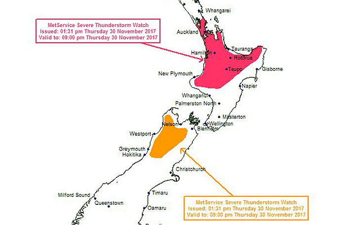
The MetService has issued a severe thunderstorm watch for the Coromandel Peninsula and the Bay of Plenty.
Scattered heavy showers and thunderstorms are expected about northern and central parts of the North Island this afternoon and evening, says the weather organisation.
"For Auckland, western Coromandel Peninsula, Bay of Plenty, Waikato, Waitomo, Taumarunui, Taupo, Taihape and the ranges of Gisborne, plus inland parts of Bay of Plenty, Taranaki and Whanganui, there is a risk that some of these thunderstorms could become severe producing localised downpours of 25 to 40mm per hour and possibly more.
"Rainfall of this intensity can cause flash flooding, slips and hazardous driving conditions.
The atmosphere remains unstable over much of Aotearoa today and Friday, with warm temperature and wind convergences giving rise to thunderstorms in many places. For detailed information on the current MetService SEVERE THUNDERSTORM WATCH go to https://t.co/GZIq9Jlbrw. ^AB pic.twitter.com/fCMVAiTHnq
— MetService (@MetService) November 29, 2017
"A Severe Thunderstorm Watch means conditions are favourable for severe thunderstorms in and close to the watch area."
The MetService says people in these areas should be on the lookout for threatening weather conditions and monitor for possible Severe Thunderstorm Warnings.
This watch affects people in the following weather forecast districts:
Auckland
Coromandel Peninsula
Waikato
Waitomo
Taumarunui
Bay of Plenty
Rotorua
Taupo
Gisborne
Taranaki
Taihape
Wanganui

0 comments
Leave a Comment
You must be logged in to make a comment.