


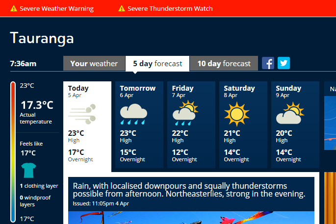
A severe weather warning and thunderstorm watch remains in place the Bay of Plenty has the remnants of ex-cyclone Debbie pummel New Zealand.
Today, the MetService is forecasting rain with localised downpours and squally thunderstorms possible this afternoon.
North-easterly winds, becoming strong in the evening.
The rain is expected to continue for the next two days, before sun moves over the region for the weekend.
'A deepening low over the Tasman Sea is forecast to cross central New Zealand overnight Wednesday and early Thursday morning and move away to the southeast later Thursday,” says the MetService.
'Heavy rain has already fallen in many places and is expected to continue until the passage of the low early Thursday morning.”
The heaviest rain is expected from Northland to Whanganui, including Coromandel Peninsula, Bay of Plenty, the Central North Island High Country, Gisborne, Hawke's Bay,Wairarapa and the Kaikoura Coast.
Rainfall totals could exceed 250mm in some areas. There is also potential for thunderstorms and downpours with hourly rainfall rates of 25 to 45mm.
'This is a significant amount of rain and people are advised to watch out for rapidly rising rivers and streams, flooding and slips.
'In addition, strong southeasterly winds are forecast about central New Zealand. Horowhenua Kapiti Coast, Nelson and Buller are expected to have the strongest winds, where gusts could reach 120 km/h in exposed places for a time during Wednesday. Winds of this strength could cause damage to trees, powerlines and unsecured structures and make driving hazardous.”
HEAVY RAIN WARNING
AREA/S AFFECTED
Northland
FORECAST
Rain with heavy falls is expected to continue until Wednesday evening. In the 25 hours from 8pm today until 9pm Wednesday, 100 to 130mm of rain may accumulate, however more than 160mm is possible about the hills in the north and east of the region. Peak intensities 25 to 45mm per hour and thunderstorms possible.
AREA/S AFFECTED
Auckland including Great Barrier Island
FORECAST
Rain with heavy falls should continue until late Wednesday evening. In the 26 hours from 8pm today until 10pm Wednesday, 120 to 180mm of rain may accumulate. Peak intensities 25 to 45mm per hour and thunderstorms possible.
AREA/S AFFECTED
Waikato and Waitomo
FORECAST
Rain with heavy falls is expected to continue until late Wednesday evening. In the 27 hours from 8pm today until 11pm Wednesday, 100 to 150mm of rain or possibly more may accumulate. Peak intensities 25 to 45mm per hour and thunderstorms possible.
AREA/S AFFECTED
Coromandel Peninsula
FORECAST
Rain with heavy is forecast to continue until midnight Wednesday. In the 28 hours from 8pm today until midnight Wednesday, 150 to 200mm may accumulate on the ranges, with lesser amounts of 100 to 150mm possible elsewhere. Peak intensities of 25 to 45mm per hour and thunderstorms possible.
AREA/S AFFECTED
Bay of Plenty and Rotorua
FORECAST
Heavy rain is expected to continue until Thursday morning. For area west of Whakatane, in the 30 hours from 8pm today to 2am Thursday, 150 to 220mm of rain may accumulate. Peak intensities of 25 to 45mm and thunderstorms possible.
For the area from Whakatane eastwards, in the 34 hours from 8pm today to 6am Thursday, 200 to 300mm of rain may accumulate, especially on the ranges. Peak intensities of 25 to 45mm and thunderstorms possible.
AREA/S AFFECTED
Taranaki
FORECAST
Heavy rain is forecast to continue until Wednesday evening. In the 27 hours from 8pm today until 11pm Wednesday, a further 200 to 300mm of rain may accumulate on the Mountain, and 120 to 160mm elsewhere, on top of what has already fallen. Peak intensities 20 to 35mm per hour and thunderstorms possible.
AREA/S AFFECTED
Taumarunui, Taupo, Taihape and the Whanganui District including Tongariro National Park
FORECAST
Heavy rain is forecast to continue until overnight Wednesday. In the 29 hours from 8pm today to 1am Thursday, 150mm to 260mm of rain may accumulate on top of what has already fallen, especially about the hills and ranges. Peak intensities of 15 to 25mm per hour.
AREA/S AFFECTED
Gisborne
FORECAST
Heavy rain, mainly south of Tolaga Bay, is expected to ease in the early hours of Wednesday morning. In the 7 hours, from 8pm today to 3am Wednesday, a further 50 to 80mm expect on top of what has already fallen. Peak intensities 10 to 15mm per hour.
Please note, further heavy northerly rain is expected about the higher ranges from Wednesday evening to early Thursday morning, 100 to 150mm of rain may accumulate from 6pm Wednesday to 6am Thursday. Peak intensities 15 to 25mm per hour.
AREA/S AFFECTED
Hawkes Bay
FORECAST
Heavy rain is expected to continue until the early hours of Wednesday morning. In the 9 hours from 8pm today until 5am Wednesday, expect a further 60 to 90mm to accumulate with the heaviest accumulations about the ranges and the coastal hills south of Cape Kidnappers. Peak intensities of 10 to 20mm per hour.
AREA/S AFFECTED
Tararua Range
FORECAST
Heavy rain is expected to continue until Wednesday afternoon. In the 19 hours from 8pm today to 3pm Wednesday, a further 100 to 150mm of rain may accumulate on top of what has already fallen. Peak intensities 15 to 25mm per hour.
AREA/S AFFECTED
Wairarapa away from the Tararua Ranges
FORECAST
Heavy rain is expected to continue until midday Wednesday. In the 16 hours from 8pm today until noon Wednesday, expect a further 80 to 120mm of rain to accumulate. Peak intensities of 10 to 15mm per hour.
AREA/S AFFECTED
Kaikoura Coast
FORECAST
Rain is expected to become heavy overnight tonight and then ease in the early hours of Thursday morning. In the 24 hours from 3am Wednesday to 3am Thursday, 100 to 150mm of rain may accumulate, with the heaviest accumulations about the ranges. Peak intensities of 10 to 20mm per hour.
STRONG WIND WARNING
AREA/S AFFECTED
Horowhenua Kapiti Coast
FORECAST
Severe southeast gales gusting 120km/h are expected during Wednesday morning.
AREA/S AFFECTED
Nelson and Buller
FORECAST
Severe southeast gales gusting 120km/h are expected in exposed places during Wednesday morning and afternoon.

0 comments
Leave a Comment
You must be logged in to make a comment.