


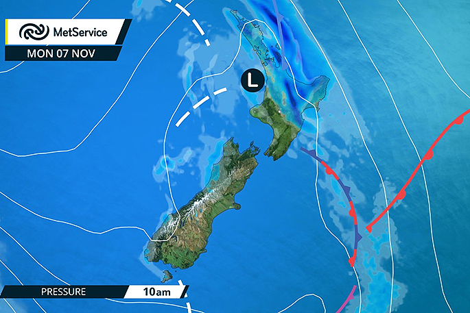
Heavy rain and possible thunderstorms are in store for the Bay of Plenty today.
The MetService has issued a severe weather watch for the region as an active front with thunderstorms is forecast to slowly cross the North Island.
This front is expected to bring periods of heavy rain to central and northern parts of the North Island overnight or on Monday, with possible squally thunderstorms and localised downpours.
'The heavy falls will gradually spread eastwards across the upper half of the North Island,” says MetService meteorologist Claire Flynn.
'As the front moves onto the North Island, a low develops on the front, causing it to move more slowly and enhancing the rainfall.”
For the Bay of Plenty, mainly east of Rotorua, rain is expected to become heavy at times and should ease in the afternoon.
'Rainfall intensities may reach 15 to 30mm per hour, especially Monday morning and early afternoon about the ranges and in any thunderstorms, which could lead to localised surface flooding.” Heavy rain is expected to ease in most places on Monday morning, though the severe weather watch continues into the afternoon for Bay of Plenty.

In addition to the watch for heavy rain, there is also a risk of thunderstorms for many parts of the North Island on Monday. 'As the front moves across the North Island, it brings a moderate risk of squally thunderstorms for areas north of about Taupo during the morning,” says Claire.
'Further thunderstorms are possible for many parts of the North Island during the afternoon and evening, due to cold air high up in the atmosphere moving across the Island.”
On Tuesday, showers gradually clear over the North Island as the low moves away to the east.
This is then followed by a settled Wednesday for the North Island.
A front and low pressure bring heavy rain to the upper North Island tomorrow. Read the Severe Weather Watch: https://t.co/bcFLKY4OUU ^CF pic.twitter.com/kNkhmIWdVK
— MetService (@MetService) November 6, 2016

0 comments
Leave a Comment
You must be logged in to make a comment.