



Sunny spells with the odd shower is the forecast for today as a deep low tracks across the country.
The MetService predicted the weather system to track across southern New Zealand yesterday, bringing gale force winds and heavy rain to much of the country.
A strong ‘southerly buster' is expected to hit this week. File photo.
The heaviest rain was expected around southern Westland and alpine regions of Canterbury south of Arthur's Pass, where 120 to 180mm of rain could accumulate by early Monday morning.
Today, the northerlies ease off down south, but are soon replaced by a strong southerly.
It will be a gusty morning in the capital too, where the strong northerlies won't take a break until the afternoon.
The southerly flick in the south will bring the temperature down, but is only a precursor for strong southerly change expected late Wednesday or early Thursday. 'We are currently expecting a strong ‘southerly buster' to come through around mid-week,” says MetService meteorologist Tom Adams.
'This fast moving front will bring southwesterly gales, colder temperatures and even the chance of some spring snow down south.”
Farmers with young livestock should be aware of a few frosty nights at the end of the week.
'The strong winds won't be long-lived,” says Tom.
'As it is followed up by a ridge bringing cool but settled weather into the weekend, but it will be a reminder that in the spring the weather can change in an instant.”
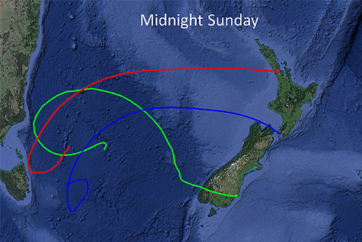
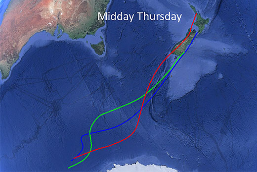
This image contrasts the origins of the warm air from the Tasman spreading over New Zealand today, and the colder Antarctic air we can expect on Thursday. Images produced using NOAA's HYSPLIT and Google Earth.

0 comments
Leave a Comment
You must be logged in to make a comment.