


This week's weather will be dominated by a ridge of high pressure which gradually slides across the country, spelling good news for those itching to get outdoors.
The final symptoms of the turbulent last few weeks of weather are a pair of fronts which scoot up the South Island today.
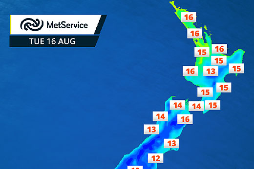
Daily high temperatures for Tuesday, August 16. Image from weatherscape at MetService.
By Tuesday, these fronts will have weakened and a stretch of settled weather begins right across the country.
With very little rain forecast for anywhere this week, it will be a good time to deal with that pile of washing which has been building up, says a statement from the MetService.
The sting will be taken out of the cold nights for many cities too. Places which have frequently dipped into the negatives overnight will stay above zero, reducing the frequency and severity of frosty starts.
With two weeks until the official start of spring, most centres can look forward to daily highs in the mid-teens this week at least.
'From sea to snow, this is the week to get back outdoors after a weather-enforced hiatus,” says MetService meteorologist Angus Hines.
'A long period swell will move up the west coast early this week for the surfers, and conditions are looking great for the ski fields, particularly around Ruapehu.”
For those interested in heading to the central plateau snow this week, MetService's new forecasts for Whakapapa and Turoa ski fields can be found here: http://info.metraweather.com/e/60812/skifields-whakapapa/b2vsbr/399900010
Despite the calm conditions, make sure you have the most up-to-date forecasts before taking on the outdoors, by checking metservice.com or on mobile devices at m.metservice.com. You can also follow our updates on MetService TV, at MetService New Zealand on Facebook, @metservice and @MetServiceWARN on Twitter and at blog.metservice.com

0 comments
Leave a Comment
You must be logged in to make a comment.