


After a week that brought torrential downpours to Auckland and gales to many others, the country is taking a respite as an area of high pressure crosses the country over the next couple of days.
The Gisborne and Hawke's Bay regions have had the highest total rainfall over the past few days, with many places topping up over 150mm during that time.
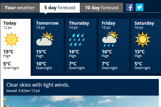
It's looking fine in the Bay today and tomorrow, but rain is forecast for Thursday and Friday. Image: MetService.
Lighter winds and dry weather is now on the cards for most for the first half of next week.
'With little cloud around, do expect some cold and frosty nights,” says MetService meteorologist Emma Blades.
Temperatures will start to pick up slightly mid-week, especially overnight, as warmer air makes its way towards us from across the Tasman Sea.
'This warmer air will be bringing plenty of rain with it, at first in a northerly flow, before turning westerly, so northern and western regions will bear the brunt of the rain,” says Emma.
According to the MetService's five day forecast, rain is expected to creep into the region on Thursday.
Rain is expected to be heavy for a period of time on Thursday, before easing on Friday.
The sun is forecast to return to the region in time for the weekend.
Rain, wind, & snow in NZ later this week. A lot of weather on the way---> https://t.co/ePtVj8cXwp pic.twitter.com/87EtFA8z8Z ^CL
— MetService (@MetService) July 11, 2016
'Once the heavy rain has passed through, the air becomes colder and we are forecasting snow for the mountains about the Divide, which should provide a great top-up to ski fields around the Southern Lakes,” says Emma.
MetService is also forecasting severe north to northwest gales in exposed parts of southern and central New Zealand on Wednesday and Thursday.
To top it off, the westerly flow is forecast to bring heavy swell of 5-8 metres for western coasts, says Emma in a media statement.

0 comments
Leave a Comment
You must be logged in to make a comment.