



The next few days will reward coastal towns and hill-dwellers with long sunny spells, while those in inland valleys may find themselves waking up to fog.
On Sunday the temperature at Hamilton airport reached just 6.3C – the second coldest maximum since records began there in 1972.
Early lambs enjoying winter sunshine on a Rotorua lifestyle farm. Photo: Elaine Fisher.
Thick fog enveloped the area, blocking warmth from the sun and cancelling flights. Conditions only cleared at around 3pm before the fog quickly rolled back in at 6pm.
Hamilton airport's coldest day on record was July 5, 1986, when the fog never broke and temperatures crept up to a meagre 3.4C.
It's not that much warmer in the Bay today, with the MetService recording a 5.2 degrees just before 7am.
It is expected to reach around 17 degrees today with a southwest breeze.
'Fog and low cloud are expected to prevail over inland parts of the North Island until Thursday, as a winter high pressure system keeps a layer of moisture trapped at low levels,” says meteorologist Tom Adams.
'Those areas escaping the cloud, including most North Island coastal towns and cities, can expect average temperatures and some long sunny spells with only a couple of showers in the mix. For the South Island, a couple of weakening fronts bring periods of rain to Southland and the West Coast, along with a brief southerly on Tuesday for Christchurch.”
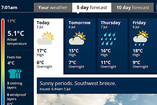
Late on Thursday a low pressure system is expected to move in from the Tasman, spreading rain across the North Island with bursts of heavy falls in the north and then to eastern areas on Friday.
As the low crosses the North Island a strong southerly moves up the country, reaching the capital on Friday and bringing gales and snow to the central North Island and Hawkes Bay ranges.
The weekend will be an improving trend, as the fresh southerly should ward off the cloud bringing fine breaks for most.

0 comments
Leave a Comment
You must be logged in to make a comment.