


Most of the country has enjoyed an unseasonably warm weekend, with Canterbury getting into the thirties.
This is set to change in the latter half of next week, as a strong cold southerly change sweeps northwards.
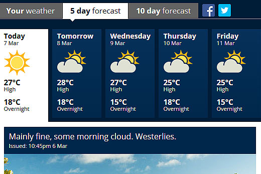
The first half of the week will see temperatures around the 28 degree mark in the Bay of Plenty. Image: MetService.
Temperatures in the Bay are expected to start dropping around Thursday when daily highs go from around 28 degrees to around 25, according to the MetService's five day forecast.
'The majority of New Zealander's have had another stunning weekend, with temperatures far above average for this time of year,” says meteorologist Emma Blades. '
The hottest spots have been in the east, with Ashburton reaching 32C on Saturday.” The warm temperatures continue through to the start of this week for the North Island and top of the South Island, with spots in the Wellington region expected to hit 30C tomorrow.
'For those who are getting tired of the hot weather and are looking forward to the cooler autumnal change, good news is in store,” says Emma, 'as a couple of cold fronts are forecast to sweep the country this week.” The first cold front moves up the South Island on Monday, bringing some heavy rain to Westland, before moving onto the North Island on Tuesday.
The really cold change is brought by the second cold front, which moves up the country on Thursday. Strong northwesterly winds are expected ahead of this front on Thursday, followed by a fresh southerly change, bringing cold air straight up from the Southern Ocean.
Northwestern New Zealand won't feel the temperature change quite so much, but everywhere else will feel significantly colder,” says Emma.
The coldest areas will be the far south and Otago, who will struggle to reach daytime maximums in the mid-teens, and drop into single digits at night.
The strong southerly flow will also bring large swell of four to five metres to southern and eastern coasts.

0 comments
Leave a Comment
You must be logged in to make a comment.