


UPDATED 10.17AM: A severe weather warning for heavy rain has been issued for the region.
The MetService says an active front and band of heavy rain currently crossing the South Island West Coast should move onto the North Island this afternoon and clear away to the east overnight.
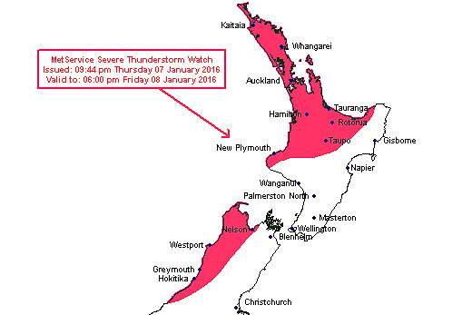
The MetService warns there is a chance for thunderstorms in the Bay of Plenty and Coromandel today. Image: MetService.
The very heavy rain over northern Westland, Buller and western parts of Nelson should ease from the south this afternoon, however, a further 40 to 80mm is likely here on top of over 100mm that has already fallen in places.
"Meanwhile, a period of heavy rain and possible thundery downpours are expected over many parts of the North Island today where a severe thunderstorm watch is in force," says a statement from the MetService.
"Significant rainfalls of over 100mm are also expected about the Tararua Range and the ranges of eastern Bay of Plenty today.
"This is a significant amount of rain falling in a relatively short period and will cause rivers and stream levels to rise rapidly."
Northwest gales are also expected to be severe for a time today over parts of Marlborough, Wellington and Wairarapa, with gusts of 140 km/h in exposed places, but these should ease late this afternoon or evening.
"Winds of this strength can cause damage to trees and powerlines as well as unsecured structures and could make driving conditions hazardous, especially about higher areas such as the Rimutaka Hill Road."
Earlier:
The Bay of Plenty and Coromandel is being warned for the possibility of thunderstorms today as a front moves across the country.
The MetService expects the front to cross the upper North Island (north of a line from Taranaki to East Cape) during the afternoon.
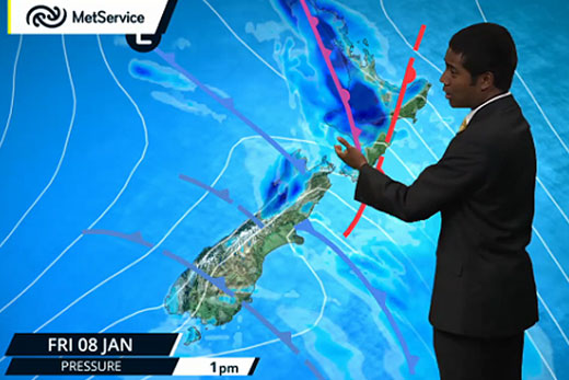
A band of heavy rain is moving over the country today. Image: MetService.
'There is a high risk of thunderstorms moving through these areas from west to east during the period with locaised rainfall rates generally expected in the 10 to 25mm/hr range,” says a statement from the MetService.
'However, there is a moderate risk that some of these thunderstorms may become severe with localised downpours of 25 to 45mm/hr possible.”
People are being warned that driving conditions will be hazardous surface flooding and poor visibility in heavy rain.
'More specifically, higher population areas such as Auckland city and Hamilton city can expect this threat to move through during the afternoon hours.”
Severe Thunderstorm Criteria
MetService uses the following criteria for severe thunderstorms in New Zealand:
Heavy rain (from thunderstorms):
Rainfall of 25 millimetres per hour, or more.
Large hail:
Hailstones 20 millimetres in diameter, or larger.
Strong wind gusts (from thunderstorms):
Gusts of 110 kilometres per hour (60 knots) or stronger.
Damaging tornadoes:
Fujita F1 (wind speeds greater than 116 kilometres per hour (63 knots)) or stronger.
Note: some tornadic systems such as funnel clouds, waterspouts and small land-based tornadoes are possible with thunderstorms that may not be classified as severe.

0 comments
Leave a Comment
You must be logged in to make a comment.