


People are being warned to batten down the hatches with the MetService issuing a severe weather warning for the Bay of Plenty and Coromandel areas.
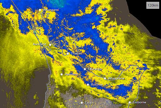
A strong and moist north to northeast flow is bringing rain to much of the northern and central New Zealand through to Sunday.
The MetService rain radar shows rain moving down the North Island. Image: MetService.
'The heaviest falls are likely about eastern areas from Northland to the western Bay of Plenty, also Mount Taranaki and the northwest of the South Island, where 100 to 150mm of rain is likely to accumulate,” says the MetService.
'For northern areas this is in addition to the significant amount of rain that has already fallen. Note, localised downpours are also possible in these areas.
'People, especially those planning outdoor pursuits, are advised this rain will cause rivers and streams to rise rapidly, with slips and flash flooding also possible. Driving conditions will also be hazardous.”
In the Coromandel, periods of heavy rain are expected to ease on Sunday morning.
In the 37 hours from 9pm Friday until 10am Sunday, 120-150mm of rain is to accumulate on top of what has already fallen. Peak intensities of 25 to 35mm per hour in localised downpours.
Auckland is in a similar predicament with heavy rain expected to ease on Sunday.
'In the 36 hours from 9pm Friday until 9am Sunday expect 90 to 120mm to accumulate on top of what has already fallen, mainly north of the Bridge and about the Hunua Ranges, with lesser amounts elsewhere. Peak intensities of 25 to 35mm per hour in localised downpours.”
Back in the Bay, heavy rain is also expected to ease late Sunday morning.
From 9pm last night to midday Sunday, 120-150mm of rain is expected to accumulate.
'Peak intensities of 25 to 35mm per hour in localised downpours.”

0 comments
Leave a Comment
You must be logged in to make a comment.