


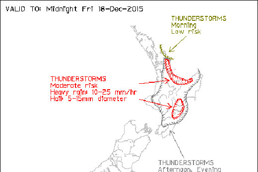
The MetService is warning Bay of Plenty residents that there is a moderate chance of thunderstorms later on today.
Conditions remain fairly unstable over the North Island today due to the combination a pool of cold air and weak pressure gradients at the surface, says a statement from the weather organisation.
The MetService is predicting a moderate chance of thunderstorms in the Bay of Plenty. Image: MetService.
'This morning, a few thunderstorms have been affecting the area offshore the Coromandel Peninsula, and there is a low risk of these also affecting the Great Barrier Island area.
'This afternoon and evening, the main risk of thunderstorms is about the Coromandel Peninsula, the Bay of Plenty and Hawke's Bay.”
These thunderstorms will be slow-moving and be accompanied by localised heavy rain and hail.
Fortunately, the low pressure and cold upper-level temperatures are moving away as we head into the weekend, meaning more settled weather is in store, says MetService meteorologist Claire Flynn.
A ridge moves across the South Island on Saturday and onto the North Island on Sunday.
'While most people will see some fine weather on Saturday, a ridge unfortunately does not mean sunshine for everybody,” explains Claire.
'Canterbury and North Otago will be mostly cloudy on Saturday, with occasional rain or drizzle.
'People in Gisborne, Hawke's Bay and Wairarapa could also expect some gloomy weather.”
On Sunday, fine weather is expected for most places in the North Island as drizzle clears out of eastern areas.
However, a warm front will slide across the South Island bringing showers to western parts, along with brief showers across Southland and Otago.
'After the warm front crosses the South Island on Sunday, temperatures will start to heat up in the east on Monday,” says Claire.
'Northwest winds will develop, which will cause the air to dry out and temperatures to rise.
'Temperatures will reach the late twenties or early thirties in many eastern areas.”
The warmth is not expected to last, however. A blustery cold front approaches from the south, reaching Southland on Monday evening and causing temperatures to drop significantly.

3 comments
Still Promising!
Posted on 18-12-2015 16:06 | By Mackka
After similar forecasts for the last three days - I'll believe it when I see it!! Bring it on!!
Typical
Posted on 18-12-2015 16:56 | By yourthumb
This is so typical of the current government - warning us of a problem, but no solution in sight. Why doesn't John Key get off his high horse and invest in a anti-weather cannon like the Chinese had at the Olympics?
Dome
Posted on 18-12-2015 19:06 | By Kenworthlogger
They could instal a huge dome over the city and we would all be safe as. Ive seen it on tv!
Leave a Comment
You must be logged in to make a comment.