


The MetService is forecasting further downpours for the Bay of Plenty as a band of rain embedded in a moist easterly flow moves over the country.
This rain band is expected to move slowly north today and lie slow moving over Hawke's Bay on Thursday.
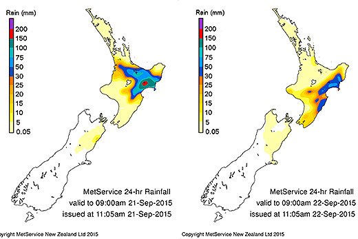
A graphic showing where most of the rain fell over the last couple of days. Photo: MetService.
The heaviest rain is expected about the ranges of Marlborough, Wairarapa and Hawke's Bay, and the eastern hills. More than 100mm may accumulate in 24 hours.
This is on top of what has already fallen in the regions this week.
Over the last couple of days, some 114mm was recorded in Gisborne in just 24 hours –almost double the typical rainfall for the entire month of September.
Napier recorded 70mm in 24 hours, which is more than the expected amount for the entire month of September.
But the top station was Pukeorapa in Hawke's Bay, which received a whopping 311mm over 48 hours.
Back in the Bay, the MetService is forecasting rain to continue through until Sunday, which is expected to be fine with south-eastlies easing.
The forecast for tomorrow is for showers with a chance of thunder in the afternoon, accompanied by light winds.
Daytime temperatures will remain around the 16 degree mark, with overnight temperatures ranging from ten-to-six degrees throughout the week.

Storm clouds brewing over Tauranga yesterday.

0 comments
Leave a Comment
You must be logged in to make a comment.