


Many people woke to freezing conditions this morning as a winter chill took hold across the country.
Further snow showers are expected for the Desert Road toady, where two-to-five centimetres of snow may settle above 800m, with lesser amounts further down.
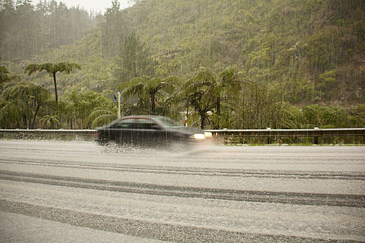
Around 4cm of graupel fell in Karangahake Gorge yesterday. The temperature was 4C. Photo: Brent Trail.
Yesterday afternoon the Bay of Plenty was pummelled with hail in conditions which saw temperatures drop down to around 4C.
Cold temperatures in the upper atmosphere also helped produce hail showers in many parts of the North Island over the weekend, says the MetService.
'Hail was reported as far north as Kaeo in Northland, and it turned lawns white in parts of Waihi,” says meteorologist Stephen Glassey.
'More hail showers are possible for the upper North Island today, however the showers are expected to become confined to eastern and southern parts of the North Island during Tuesday.”
Stephen says a ridge of high pressure is building over the South Island, which will bring clear skies and light winds for the next few days.
'The North Island ski fields saw a snow base now over 2m at Whakapapa,” he adds, 'although mountain goers there will need to wrap up warm against the cold southerly flow which is expected to persist until late on Wednesday.”
The light winds over the South Island will bring severe overnight frosts in many areas, and parts of the North Island will also see frosts.
Temperatures begin to warm up towards the end of the week as a northerly flow develops over New Zealand.
However, a low is expected to approach from the Tasman Sea on Friday and move over the country during the weekend.
'This will probably bring a return to colder wetter weather,” says Stephen
'As well as updating forecasts, we'll also be keeping the All Blacks updated on the possible effect of this on the Bledisloe Cup rugby decider at Eden Park on Saturday night.”

0 comments
Leave a Comment
You must be logged in to make a comment.