A state of emergency has been declared for the Bay of Plenty.
Bay of Plenty Civil Defence Emergency Management said it has received support from the local mayors to declare a state of local emergency.
“This is a precautionary approach to ensure controllers and others with extraordinary powers can respond quickly and efficiently, to deliver actions that will help keep people safe during a response,” a spokesperson said.
“This includes closing roads or public places, undertaking works, removing or securing dangerous structures and material, and providing first aid, food or shelter.
“You can still go about your daily business under a state of local emergency, but make sure you listen to and follow any instructions from civil defence and emergency services.”
A red rain warning, the first for 2026, is in place for Coromandel, Bay of Plenty and Rotorua.
In the 24 hours from 9am Wednesday to 9am Thursday, a further 180mm to 240mm of rain is expected on top of what has already accumulated.
Peak rates of 25mm/hr to 40mm/hr could be expected in downpours from Wednesday evening, MetService warned.
Western Bay of Plenty mayor James Denyer said the state of local emergency was “precautionary”.
“We’ve had direction from the minister (Hon Mark Mitchell) to not hold back on declaring a state of emergency.”
Denyer said councils wanted to be “ahead of the game” as projected weather was expected to worsen.
“It is only raining, but it’s continuous heavy rain.
“If people have to evacuate, we’d rather that happens in a controlled way rather than late at night or when conditions are really bad.
Beach update
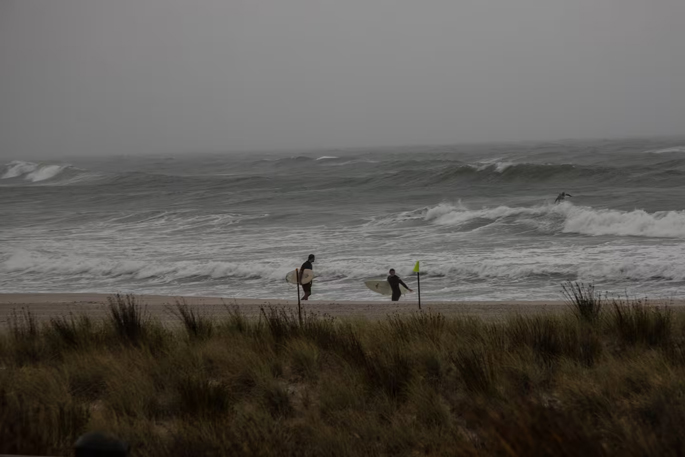
Surf Lifesaving NZ eastern region manager Chaz Gibbons-Campbell said water conditions were “pretty dangerous”.
“We’re seeing some large swells, upwards of two and a half metres, with some pretty strong onshore winds.“
Mount Maunganui Beach, Omanu Beach, and Papamoa Beach were all red-flagged today, meaning swimming was not advised.
“Stay off the beaches and stay out of the water.“
Gibbons-Campbell said he spoke with the head guard at Mount Maunganui, who told him people were still swimming there.
“We’re just keeping an observational team on at Mount Maunganui because there are still people going in the water.”
Gibbons-Campbell said beaches had passed high tide earlier this morning, and the current outgoing tide was “doubly doubly dangerous.”
He instructed all lifeguards to finish early due to unsafe road conditions and patrols were closing at 2pm at most locations.
“I really want to emphasise that our lifeguards are finishing early today across our beaches, and it’s not safe for them to go in the water, so we don’t want members of the public putting themselves at risk.”
Emergency alert
An emergency alert has been sent out across the Bay of Plenty advising people to put their safety first as severe weather is forecast for the region.
In the alert from the Bay of Plenty Civil Defence Emergency Management team at 11.47am, people were advised to act quickly if they saw rising floodwater.
“Do not try to walk, play, swim or drive in floodwater.
“Avoid all non-essential travel. Bring pets indoors and move livestock to high ground where possible.”
 An emergency phone alert for a red servere rain warning has been sent out BY MetService in the Bay of Plenty.
People were also advised to be prepared to evacuate.
“Keep a bag close. If you are in immediate danger, call 111.”
Tauranga City Council duty controller Nigel McGlone said it was monitoring the weather situation alongside the Bay of Plenty Civil Defence Group.
At this stage, he said there were no road closures in Tauranga or areas causing concern.
A council statement said it had activated its emergency operations centre as a precaution, with a dedicated team ready to respond to any emerging issues.
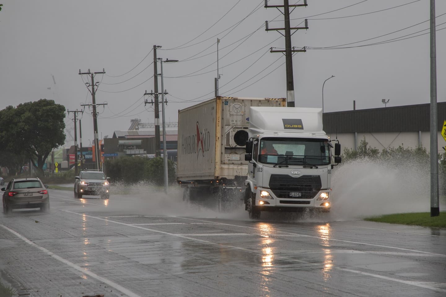
 Rain is expected to fall in Tauranga until around 9am tomorrow. Photo / Kaitlyn Morrell
People could call 07 577 7000 24/7 to report weather-related issues such as flooding, fallen trees, or slips.
MetService said the current weather was being driven by a strong and extremely humid northeasterly flow that precedes a tropical low forecast to approach New Zealand from the north today.
In the 24 hours to 2pm today there has been 123mm of rain at Waihi Beach, 79mm at tauranga, 78mm at Matakana, 50mm at Te Puke, 41mm at Kawerau, 31mm whakatana, 22mm Rotorua and 14mm Opotiki
The current red warning for heavy rain is in force until 9am tomorrow.
MetService meteorologist Lewis Ferris said heavy rain has been affecting the more western areas of Bay of Plenty today but was expected to spread everywhere this afternoon, .
“It looks like peak intensities are due through the hours of darkness into Thursday morning.”
Ferris said rain rates have been up to around the 15mm/h mark so far but from this evening there’s risk of downpours which could see areas reach 40mm/h.
He said strong easterly winds, likely more noticeable around western areas, were also forecast.
“The rain would ease from the west after dawn on Thursday - eastern areas might hold onto some showers past midday but most places look to dry out as wind gradually turn around to the west.
“Friday has blustery westerly winds, risk of showers peppering the region, more likely around evening which marks the arrival of some cooler air for the weekend.”
Bay of Plenty Civil Defence Emergency Management Group said the Bay and other affected regions could expect 180mm to 240mm of rain, with peak rates of 25mm/hr to 35mm/hr.
“We know this news might be worrisome, especially to those districts who have experienced significant rainfall in the last few weeks.
“Streams and rivers may rise rapidly, and surface flooding is possible, so if you see rising water, do not wait for official warnings – head for higher ground and stay away from floodwater. Never try to walk, play, swim or drive in floodwater.”
Driving conditions
A Katikati resident told the Bay of Plenty Times his workplace, which has many staff travelling in vehicles across the Bay, had sent all staff home effective immediately.
“Due to the BOP Civil Defence severe rain warning, they’ve asked us all to go home and work from there as a precaution.”
NZ Transport Agency said in a traffic bulletin that State Highway 2 in the Karangahake Gorge was likely to close overnight around high tide “as it has already reached maximum levels”.
The agency said road users should be aware of possible flooding, especially in low-lying areas and near rivers, slips, fallen trees, reduced visibility and hazardous driving conditions, and potential road closures or delays.
Heavy rain could also cause potholes to form or worsen, creating additional hazards for drivers.
 Rain has been steadily falling in the region today. A red rain warning is currently in place. Photo / Jo Jones
“Driving through flood water can be extremely dangerous,” the agency said.
“Just 15cm of water can sweep a person off their feet, and 30cm can carry away most vehicles. Motorists should be aware of branches and other debris they may not be able to see under the surface of flood waters.”
People are asked to be mindful of contractors who could be out clearing hazards off the road, and drive slowly through work sites.
Bay of Plenty Civil Defence advised people not to travel unless it was an emergency, as there may be slips, fallen trees or surface flooding on roads. The organisation recommended drivers check with NZTA or their local council website for any road closures.
 A red rain warning is now in place for the Bay of Plenty and Rotorua. Image / MetService
Coromandel evacuations
In the Coromandel, flooding was being reported on Wade Rd, south of Whitianga. Surface flooding was also reported around the region.
SH25 from Whitianga to Tairua was closed, NZTA reported.
“SH25 is also closed south of Whitianga near Wade Rd. This means Whitianga can not currently be accessed via SH25 from north or south,” NZTA said on Facebook.
“SH25 is closed between Discovery Dr and Simpson’s Beach due to flooding. It is expected to remain closed for several hours.”
About 200mm to 250mm of rain was expected to fall in the Coromandel Peninsula until 6am on Thursday.
Thames-Coromandel District Council advised people in a low-lying area to “please move to higher ground immediately”.
“The Coromandel Peninsula is experiencing significant rainfall and more rain is expected today. Rivers and creeks are rising rapidly,” the council said.
“We ask campground owners to proactively stay alert and manage any of their hazards.”
The Cooks Beach Community Response Group has been activated and was operating from the Cooks Beach Fire Station.
The group was working alongside the Cooks Beach Campground to support the evacuation of about 35 to 40 campers, council said.
“We ask campground owners to stay alert and proactively manage hazards at their sites.
“Please take this warning seriously and act now to keep yourself and others safe.”
 Floodwaters cover the highway on the outskirts of Whitianga, which is this morning cut off from the rest of the Coromandel Peninsula. Photo / Supplied
Cooks Beach Resort manager Callum Murray said he had evacuated campers but still had caravans and campervans on site.
“I’ve got a car almost completely underwater.”
He said the campground was about 1.5m over the “normal” water level.
“The bottom half of my camp is now a lake.“
Murray said the resort had about 100 people on site at this stage who were being evacuated to the care of locals.
“The civil defence unit is now set up, so they’ve got a sanctuary for people down at the fire station, but at this stage, vehicles can move, so camper vans I’ve just got on high ground.”
New road closures: Kennedy Bay Rd near Mangatu Rd is closed.
Fire alarm siren malfunction
In a post on Facebook, the Thames-Coromandel District Council said the Fire and Emergency NZ fire alarm in Coromandel Town malfunctioned on Tuesday evening, causing it to sound continuously for about five minutes in a steady tone.
“This was not a tsunami alert – there have been no tsunami alerts.
“We’re aware of the concern and anxiety this may have caused Coromandel Town residents, and can assure everyone that there is no cause for alarm.
“FENZ is investigating the issue and fixing it.”
State Highway 2, Waioweka Gorge closure
SH2 through the Waioweka Gorge remained closed.
Roading crews working to clear around 40 slips along the highway have paused work today.
“With weather set to worsen over the day, crews will take a pause, rest, and allow the weather to pass before reassessing the site and resuming clearing work once safe to do so,” NZTA said in a statement.
 There are multiple slips along SH2, between Ōpōtiki and Gisborne. Image / NTZA
“SH35 remains open, however, it is not a reliable detour route while weather is severe.”
SH2 south of Gisborne and SH5 remained open if people must travel.
Additional crews were on standby to respond to any incidents on the detour routes.

0 comments
Leave a Comment
You must be logged in to make a comment.