A strong burst of heavy rain is expected to sweep across the region today, with MetService issuing an orange rain warning for areas about and east of Rotorua from 9am today to 2am tomorrow.
The warning is also in place for Tauranga and the Western Bay of Plenty.
Forecasters are predicting 80–120mm of rainfall, with peak intensities of 15–25mm/h from this afternoon.
Conditions may worsen east of Whakatāne this evening, where rainfall rates could rise to 25–40mm/h, accompanied by possible thunderstorms.
While the event is significant, the likelihood of an upgrade to a red warning remains minimal, MetService said in its latest weather update.
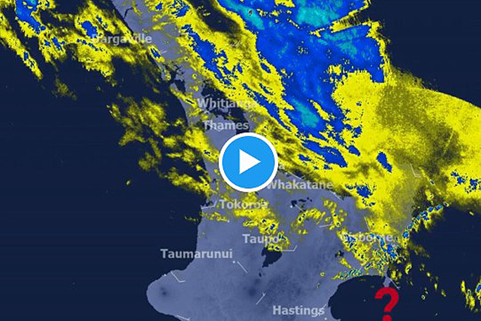
Rain Band Moving South
— MetService NZ (@MetService) December 28, 2025
Heavy Rain Warnings are still in their early days, so accumulations are just starting to climb.
You can see two different directions of rain due to different wind flows at different levels of the atmosphere!
Check out the radar here:… pic.twitter.com/zmUEP3SLSF
Expected Impacts
Local authorities warn that streams and rivers may rise rapidly, increasing the risk of:
Surface flooding
Slips and debris flows
Hazardous or reduced‑visibility driving conditions
Disruptions on rural and coastal roads
What residents should do
Emergency managers advise residents to take practical steps ahead of the downpour:
Clear drains and gutters to reduce flood risk.
Avoid low‑lying and flood‑prone areas.
Drive with extra caution, particularly from late afternoon when rain is expected to intensify.
Heavy rain is likely to be highly localised at times, and conditions may change quickly throughout the evening.

1 comment
No Suprises There.
Posted on 30-12-2025 07:22 | By Yadick
This weather pattern has been the same for years and years. We don't really get our beautiful endless weeks of sunshine beginning until mid January.
Somehow all these heavy deluges don't stop a water crisis being declared in Tauranga every Summer. Perhaps TCC you should listen to your constituents like moerporks awesome idea of a desalination plant to end all the woes. You need to realise that your ideas don't need to always come from overpaid seat warmers. Just maybe as we roll into 2026 you could make listening to and hearing your community, your city, a part of the plan. Believe it or not the reality is there's people outside of Council with some great ideas that can be built on.
HAPPY NEW YEAR EVERYONE 🥳
Leave a Comment
You must be logged in to make a comment.