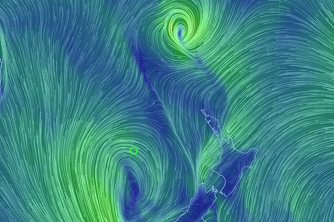
Cyclone Cook is now expected to make landfall in an area from Coromandel Peninsula to Western Bay of Plenty around 6pm Thursday.
MetService says the cyclone is travelling south through the North Island and is expected to track over central New Zealand around midnight Thursday, then pass just east of Banks Peninsula around 6am Friday, before continuing south.
Although fast-moving, Cyclone Cook will be destructive and MetService Expert Meteorologists have issued Severe Wind Warnings for the whole of the North Island apart from Northland which is on a Severe Wind Watch.
'Given the current track of Cyclone Cook, our concern is for Coromandel Peninsula, Bay of Plenty, Auckland and Waikato where we are expecting wind gusts of 150km/h or more and heavy downpours of rain,” says Communications Meteorologist Lisa Murray.
'In addition, this system will also cause rain and damaging wind for the rest of the North Island as it moves south, and will then impact eastern areas of the South Island.”
As Cyclone Cook approaches north-facing coastal areas from Northland to Hicks Bay, people should also prepare for large swells which will contribute to coastal inundation and erosion.
'This is an extreme weather event and people should not take this warning lightly. Please consider securing property, moving animals to safety, and cancelling or postponing travel where possible,” says Lisa.
People should be prepared in case of loss of power or becoming isolated due to road closure and are advised to listen to their local Civil Defence for updates.
Many places are already getting heavy rain from the low and its preceding trough which came from the Tasman Sea.
Cyclone Cook is expected to arrive at the tail end of that rain, with little or no reprieve in between.
'Soil is already saturated after last week's rain event, so, add the rain from the Tasman Low and then the wind and rain from Cyclone Cook and you have the ingredients for large scale damage such as fallen trees, landslips and rapidly-rising rivers and streams.”
You can get the latest severe weather warnings and watches at http://info.metraweather.com/e/60812/AllWarnings/cnrd6j/525204697
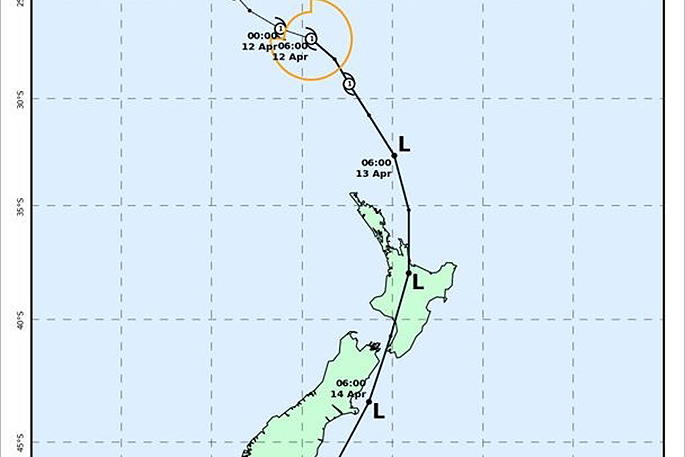
Latest track map for TC Cook based on 11/1800Z analysis. Note that all times on this chart are NZ local time.
Residents urged to prepare for Cyclone Cook
Whakatane District residents are urged to be prepared as the region is set to be hit with more heavy rain and wind later today.
Cyclone Cook is expected to hit the region with more than 200mm of rain expected to drop over the coming days. The event is expected to be similar in strength to Cyclone Debbie.
As the ground throughout the region is already saturated from Cyclone Debbie, Civil Defence are urging all residents to:
- Have an evacuation plan in place for your immediate family and pets
- Have a supply of fresh food and enough clean water for three days ready to go
- Clear gutters and storm water grates of any debris
- Monitor the weather situation closely - checking online for Civil Defence updates or on 1XX FM
- Stay alert to the risks - this includes flooding and any cracking or shifting of ground
- Avoid travelling during heavy weather unless necessary.
'We're monitoring the weather situation very closely, paying special attention to areas like stop banks, river levels and slips, but want residents to be prepared for similar conditions to last week,” says Regional Council duty flood manager Peter Blackwood.
'What we're looking at is an unpredictable weather event and while we're monitoring the situation closely and will continue to provide updates, be prepared and if you think your safety is at risk evacuate first.”
For families already affected in Edgecumbe:
- The Matahina Dam has been lowered to its lowest ever operational level
- There are 17 pumps along the Rangitaiki River running 24 hours a day to remove water from already flooded areas
- Stop bank breaches at Edgecumbe have been closed and secured and the Rewatu Road breach on the Whakatāne River has been repaired
- At this stage all Whakatāne River stop banks are secure, with ongoing monitoring being undertaken
- Council will continue to inspect buildings with the aim of getting families back into their homes as soon as possible
- All initial building inspections are expected to be completed this afternoon - depending on weather and access
- Zone 1 and 2 residents that have been able to reoccupy their homes are advised to be prepared to leave if another flooding event takes place
- Zone 3 and 4 residents with assisted access will continue to be able to visit their homes while the weather remains stable. They are advised to collect their pets when accessing their property
- If there is a need for further evacuations, warnings will be issues as soon as possible. Fire sirens will be activated and emergency services personnel will be driving around with sirens on.
If members of the public require sandbags, free sandbags are available from Tracks Concrete, 19 Arawa Road, Whakatane, or by calling 07 307 0581.
People can sign up for Bay of Plenty Civil Defence text alerts by texting the two letters for your area to 2028:
- TA – Tauranga
- WB – Western Bay
- KA – Kawerau
- WH – Whakatāne
- RO – Rotorua
- OP – Ōpōtiki
People can also follow the Bay of Plenty Civil Defence Facebook page atwww.facebook.com/bopcivildefence or visit the Bay of Plenty Civil Defence website atwww.bopcivildefence.govt.nz for information about how to get ready before an event.
For radio updates listen to 1XX FM.

0 comments
Leave a Comment
You must be logged in to make a comment.