The severe weather warning lingers in the Bay as more heavy rain is expected.
A warning is in place for Coromandel Peninsula, Rotorua, Taranaki, Tararua, Wairarapa, Manawatu, Kapiti Horowhenua, Wellington, Marlborough, Christchurch, Northland, Auckland, Great Barrier Island, Hawke's Bay, Waikato, Waitomo, Wanganui, Taumarunui, Taupo, Nelson and Buller.
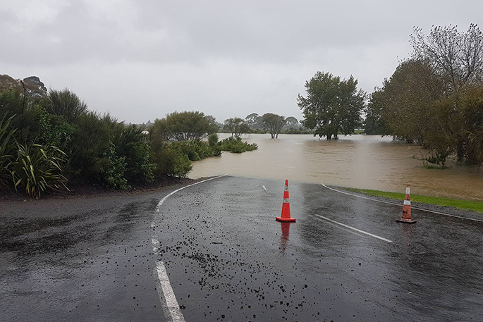
Earlier reports to SunLive alleged that floodwaters were threatening the Kaituna stopbanks, but this has not been confirmed and a Regional Council spokesperson says there's no evidence of this.
A deep low is moving southeast across central New Zealand tonight, and is expected to lie to the east of the Banks Peninsula on Thursday.
"It's followed by a ridge of high pressure on Friday. Heavy rain is expected to continue until the passage of the low in the early hours of Thursday morning, but continue about parts of Marlborough and Canterbury through to Thursday night," says the MetService.
"The heaviest rain is expected in Bay of Plenty through to about dawn Thursday with
the potential for thunderstorms and downpours producing hourly rainfall rates of 25 to 45mm."
For the South Island, the heaviest rain is expected about the Kaikoura Coast and Banks Peninsula until Thursday night.
People are advised to watch out for rapidly rising rivers and streams, surface flooding and slips.
In addition, southwest gales are expected over Banks Peninsula and the Kaikoura Coast from Thursday morning to Thursday night, with gusts of 130 km/h in exposed places.
Winds of this strength could cause damage to trees, powerlines and unsecured structures and make
driving hazardous.
======================
HEAVY RAIN WARNING
======================
AREA/S AFFECTED: COROMANDEL PENINSULA
FORECAST:
Further bursts of heavy rain are expected until midnight Wednesday.
In the 4 hours from 8pm, a further 20 to 40mm may accumulate on top of what has already fallen, especially on the ranges. Peak intensities of 15 to 25mm per hour and thunderstorms are possible.
AREA/S AFFECTED: BAY OF PLENTY AND ROTORUA
FORECAST:
Heavy rain is expected to continue until early Thursday morning.
For area west of Whakatane, in the 5 hours from 8pm today to 1am Thursday, a further 30 to 60mm of rain may accumulate. Peak intensities of 20 to 35mm per hour and thunderstorms possible.
For the area from Whakatane eastwards, in the 10 hours from 8pm today to 6am Thursday, a further 70 to 120mm of rain may accumulate, especially on the ranges. Peak intensities of 25 to 45mm and thunderstorms possible.
AREA/S AFFECTED: TARANAKI
FORECAST:
Heavy rain or showers should continue until midnight tonight (Wednesday). In the 4 hours from 8pm to midnight tonight, a further 40 to 60mm may accumulate on Mt Taranaki, with 20 to 30mm elsewhere.
Peak intensities 10 to 25mm per hour.
AREA/S AFFECTED: TARARUA RANGE
FORECAST:
Rain is expected to continue until early Thursday morning. In the 6 hours from 8pm today to 2am Thursday, a further 50 to 60mm of rain may accumulate on top of what has already fallen. Peak intensities 10 to 20mm per hour.
AREA/S AFFECTED: KAIKOURA COAST
FORECAST:
Periods of heavy rain are expected until Thursday morning. In the 10 hours from 8pm today to 6am Thursday, 60 to 90mm of rain may accumulate on top of what has already fallen. Peak intensities of 10 to 20mm per hour.
AREA/S AFFECTED: BANKS PENINSULA
FORECAST:
Rain becoming heavy overnight tonight, and continue through to Thursday night. In 23 hours from 1am to midnight Thursday, 100 to 130mm may accumulate. Peak intensities 10 to 15mm per hour.
=======================
STRONG WIND WARNING
=======================
AREA/S AFFECTED: KAIKOURA COAST AND BANKS PENINSULA
FORECAST:
Severe gale southwesterlies are expected to develop Thursday morning and persist into Thursday night. Gusts of 130 km/h expected in exposed places.

1 comment
Token gesture signs...
Posted on 05-04-2017 21:26 | By penguin
"We can only do our best'' they were heard to say!
Leave a Comment
You must be logged in to make a comment.