


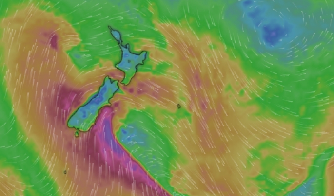
A powerful southerly change is set to sweep across the country today, bringing strong winds, bone-chilling conditions and dumping snow to low levels.
Thunderstorms have already started rumbling across Cook Strait and North Taranaki Bight this morning, while snow is expected across alpine passes in the south and the Desert Road early tomorrow.
On the Crown Range Road, between Queenstown and Wānaka, snow is expected to fall to 700m this morning, and to 400m by evening. Road users are warned to expect one to three centimetres to accumulate above 700m.
Snow has been falling on the Milford Road since last night, with snow showers forecast to affect five other southern alpine passes, and the Dunedin to Waitati highway.
MetService said a low-pressure system was directing “bitterly cold” conditions up the country, beginning in the far south before working its way to the top of New Zealand by the end of tomorrow.
Before the southerly change, MetService meteorologist Braydon White told the Herald a front would push over the North Island today, bringing a wet start for most.
By midday, the worst of the weather was expected to have passed, but there would be showers throughout the day.
“We do have some thunderstorms expected, mostly for the west of the South Island. They’ll be quite squally with some decent gusts and some hail as well.”
He said there was a chance these thunderstorms could make their way into the Kāpiti Coast and western Taranaki.

A strong southerly change is set to sweep across the country. Photo / George Heard
Severe weather alerts
Severe wind and snow alerts are currently in place across southern and eastern flanks of the South Island, and alpine passes.
Snow is expected to fall to 200m on the highway connecting Dunedin and Waititi this afternoon.
A strong wind watch is in place for Christchurch and Banks Peninsula, as well as the Canterbury Plains about and east of Lincoln, until 1am tomorrow.
Coastal Otago is under the same wind watch until 10pm, and coastal Southland and southern Fiordland until 4pm.
The same watch is in place for Coastal Marlborough south of Ward from 7pm until 1am tomorrow.
A road snowfall warning is in place for the Lewis Pass (SH7) until 4am tomorrow.
The same snowfall warning has been issued for Arthurs Pass (SH73) until 1am tomorrow, Porters Pass (SH73) until 6am tomorrow, Milford Road (SH94) until 6pm, the Crown Range Road until midnight and Lindis Pass until 3am tomorrow.
In the North Island, the Desert Road is expected to be covered in up to 2cm of snow tomorrow morning.
‘Subantarctic’ air, low-level snow
MetService described the return to cold, wet and windy conditions over the next few days as a “strong wintry blast”.
“By the time you hit the end of Saturday, pretty much everywhere in New Zealand will have gotten the taste of this cold snap,” White said.
Temperatures were expected to be among the coldest so far this year.
On Saturday night, the temperature at Mt Cook is expected to drop to -7C, with widespread frosts for many other places.
The North Island, including Hamilton, Rotorua and Taupō, was looking at -4C.
Frost was also possible in Auckland.
MetService said the “subantarctic” air, combined with the wind chill, was likely to make temperatures feel even colder.
According to a post by the Washington Post’s global weather writer and meteorologist, Ben Noll, the Southern Hemisphere’s “snowiest spot” over the next two weeks is forecast to be Aoraki/Mt Cook.
Noll said 340cm of snow over this period was likely.
Snow in Antarctica, Australia, New Zealand, South Africa and South America? ❄️
— Ben Noll (@BenNollWeather) July 29, 2026
Check, check, check, check and check!
The Southern Hemisphere's snowiest spot over the next two weeks is forecast to be Aoraki / Mount Cook, New Zealand, with 134 inches (340 cm) of snow. pic.twitter.com/lhOcn3R731
Sunday morning was expected to see a return of clearer skies for most of the country and widespread frosts.
“Looking towards the start of the working week, another cold front approaches the country, bringing some more showers for western and southern areas,” MetService said.
Sign up to The Daily H, a free newsletter curated by our editors and delivered straight to your inbox every weekday.

0 comments
Leave a Comment
You must be logged in to make a comment.