


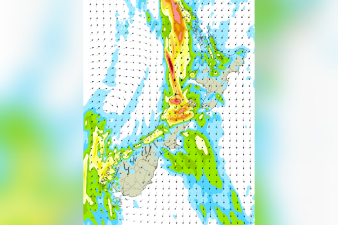
People are being urged to keep up with the forecast as the MetService warns incoming heavy rain is likely to be a “significant weather event” affecting large parts of the country, including the Bay of Plenty, Rotorua and Coromandel regions.
Orange heavy rain warnings are already in force for parts of the South Island today as a moist subtropical airflow delivers wet weather and unusually warm temperatures across much of New Zealand.
MetService said the heaviest falls are forecast for parts of Tasman, Nelson, Buller, Westland and Fiordland, where several hundred millimetres of rain could accumulate over 36 to 41 hours.
Tasman northwest of Motueka is forecast to receive 350mm to 400mm of rain, with more than 500mm possible in the ranges.
There is a moderate chance of this warning being upgraded to red.
The Richmond and Bryant Ranges, including Nelson City and the Rai Valley, could see 300mm to 400mm of rain, while Westland south of Hokitika is forecast to receive 350mm to 500mm about the ranges.
Thunderstorms are also possible in some western areas.
MetService forecaster Gerard Bellam said a warm, moisture-laden northeasterly flow, fed by air originating near New Caledonia, was driving the unsettled conditions.
“We’ve got a warm sort of moist north to northeast flow, and there’s an embedded trough in there,” Bellam said.
The system is expected to bring heavy rain to northern and western-facing parts of the country, with orange heavy rain warnings in place for parts of the South Island and Northland.
Rain watches have also been issued for Bay of Plenty, Coromandel, Rotorua and Taupō.
While the rain will be the main concern in warning areas, much of the country is also set to experience temperatures well above average for late autumn.
MetService warned the prolonged downpours could cause rivers and streams to rise rapidly, with surface flooding, slips and hazardous driving conditions possible in affected regions.
Auckland is expected to reach 18C today with cloudy periods and isolated showers.
Conditions are forecast to deteriorate tomorrow, with persistent rain developing in the afternoon and temperatures ranging from 16C overnight to 19C during the day.
Tauranga and Hamilton are forecast to reach 19C today, with rain becoming more widespread on Monday.
Wellington will see mostly cloudy conditions and occasional rain developing this evening, with temperatures climbing to 17C today and 18C tomorrow.
Christchurch is forecast to reach a notably mild 21C today before rain arrives tomorrow afternoon. Dunedin is expected to see a high of 17C today and tomorrow, with periods of rain clearing early Monday.
Bellam said overnight temperatures would be the standout feature of the forecast.
“Auckland and Wellington are about 6 degrees above average for the minimum, and Christchurch is really warm. It’s 9 degrees above average, and Dunedin 6 degrees.”
The warmer-than-normal nights are expected to continue for several days as the subtropical air mass remains over the country.
“It’ll be warm. Above-average daytime maximums, but those quite warm nights for the next few days with that subtropical air mass coming down.”

0 comments
Leave a Comment
You must be logged in to make a comment.