


- Cyclone Vaianu has moved through the central North Island, with MetService warning it remains a “multi-hazard, potentially life-threatening event”.
- While an orange heavy rain warning has lifted for the Bay of Plenty and Rotorua, a red strong wind warning remains in force until 9pm.
- Multiple weather‑related incidents across the region including fallen trees, downed power lines, lifted roofs and power cuts.
- Several Bay of Plenty state highways will remain closed overnight.
- A local state of emergency has been declared in multiple areas including Tauranga, Western Bay of Plenty, Whakatāne and Waikato including Coromandel.
6.52pm: This live story is closing for the night.
Live Cyclone Vaianu updates will continue at nzherald.co.nz this evening.
Thank you to everyone who read, and we hope you have come through the cyclone chaos safely.
Do you have a Cyclone Vaianu story idea or news tip? Email [email protected]
6.29pm: All Community Emergency Hubs across the Western Bay of Plenty District have stood down now that the peak of Cyclone Vaianu has passed.
The hubs were activated as a precaution to give people a safe place to go if they felt unsafe at home, particularly in coastal and low‑lying areas, the council said.
About 60 people were supported across the hubs and local marae.
The council's emergency management controller Peter Watson said the hubs worked as intended, providing reassurance and a warm welcome during an unsettling time.
He said marae were vital during the emergency, with their support providing invaluable shelter and community connection when people could not return home right away.
While conditions have eased, residents are urged to stay cautious as clean‑up and recovery work continues.
6.15pm: Several Bay of Plenty state highways will remain closed overnight, NZ Transport Agency says.
Crews will be assessing and clearing the network from 7am Monday, reopening roads when safe.
SH30 between the SH33/SH30 Te Ngae Junction and the SH30/SH34 intersection at Rotomā and Lake Ōkataina remains closed due to fallen trees, as does SH33 between Te Ngae Junction and Paengaroa.
In Ōpōtiki, SH35 is closed between Goring Street and Gow Road because of flooding, while the stretch between Ōpōtiki and Okitu, just north of Gisborne, is also closed due to fallen trees, with access limited to residents and emergency services.
SH2 between the Matekerepu and Wainui Road roundabouts through to Ōpōtiki remains closed due to multiple fallen trees, while the SH2 Waioweka Gorge closure is expected to lift at 10am Monday.
Meanwhile, floodwaters are receding across the Coromandel Peninsula, with closed sections of State Highway 25 set to reopen as conditions allow.
The Hikuai area is expected to be among the last to reopen, while a watch remains in place on water levels through the SH2 Karangahake Gorge.
NZTA urged motorists to drive to the conditions and watch for flood debris and speed restrictions.
6.05pm: A Mount Maunganui cafe owner says he was “overrun by demand for ice cream” today, despite Cyclone Vaianu and a local state of emergency.
Wave Cafe owner Guido Bachmann opened his beachfront, mobile cafe on Marine Parade.
“I didn’t realise that Kiwis need ice cream to watch hurricanes.”
He said most customers thanked him for being open and told him it was a good idea.
“Nobody seemed too worried about the alert and the waves.”
Bachmann said he was slightly worried about his site being damaged.
But if the weather worsened, he would consider closing for the day.
Dylan Chivell and Adam Gilliland were at Mount Maunganui Main Beach at about 3.30pm.
Gilliland said cabin fever had set in, so he decided to “get out and get amongst it”.
He said the weather was bad this morning, but he thought it would have been worse.
Gilliland had grab bags packed for his family as a precaution.
The rest of his Sunday involved movies on the couch.
Felicity Hatcher and Carrick Corson were on their way to the gym and stopped at the beach to see the waves.
Hatcher said the weather had been what she expected due to weather warnings.
“We had Sunday admin planned, so the weather didn’t really disrupt that.
“We can always postpone that for tomorrow. It’s better to be safe than sorry.”
Corson said they didn’t have any grab bags packed but were ready to get up and go if they needed to evacuate.
5.51pm: A windsurfer, surfers and even a boogie boarder have been seen out testing the cyclone conditions today.
Michael Lenihan filmed a windsurfer in Welcome Bay, Tauranga.
He said the weather was "not too bad" at the time.
"Bit of rain, bugger-all wind."
5.17pm: MetService meteorologist Devlin Lynden said the centre of Cyclone Vaianu is now tracking south‑southeast, sitting near Lake Waikaremoana.
He said the system is still generating significant rain and strong winds across much of the North Island, including Bay of Plenty.
Rotorua Airport has recorded 79.2mm of rain over the 24 hours to about 5pm, with higher inland totals reaching up to 120mm in exposed hill country.
Tauranga Airport recorded 31.1mm, while an inland station east of Whakatāne reached 40mm.
Ōpōtiki recorded 36mm.
Lynden said damaging wind gusts have been a major feature of the cyclone.
Whakatāne recorded a gust of 94km/h before its station stopped reporting at midday.
The cause was not yet confirmed but possibly linked to wind damage or a power outage.
Tauranga gusts peaked at 80km/h this morning and were now gusting around 60km/h.
Rotorua reached 85km/h at midday, easing to 55km/h. Inland Mamaku recorded a peak gust of 125km/h earlier today.
Lynden said conditions will gradually ease tonight as the cyclone continues moving south, with rain breaking into showers and winds steadily dropping through the evening.
4.38pm: Tauranga City Council said several emergency support sites are now preparing to close as Cyclone Vaianu moves away from the city.
Mercury Baypark will close at 5pm, the Matua Bowling Club at 4pm and Hungahungatoroa Marae is also preparing to close for the day.
Huria Marae, Wairoa Marae and Mangatawa Marae will remain open overnight.
About 80 people sought shelter at marae across Tauranga, and five people self‑evacuated to Mercury Baypark, the council said.
Residents who could not return home were encouraged to stay with friends or whānau where possible.
The MetService red warning for strong wind continues until 9pm, with the orange warning for heavy rain in force until 5pm.
Fraser St near Fraser Cove has reopened. It closed about midday amid flooding concerns.
The council asked that residents report surface flooding, blocked or damaged roads or walkways, and fallen trees by calling 07 577 7000 with the exact location.
The council's Emergency Operations Centre will remain active tonight and ready to respond.
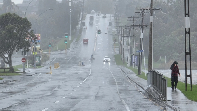
4.18pm: Western Bay of Plenty District Council recovery manager Jo Lynskey said more than 60 people have taken shelter at marae across the district.
She said community emergency hubs were activated but saw only small numbers, as many residents had already self‑evacuated or gone to stay with family and friends.
Lynskey said the council is now looking at closing some community hubs, starting from Waihī Beach and moving east as the weather progresses down the coast.
Marae may remain open longer depending on the needs of those staying there, with decisions made in partnership with iwi.
Rotorua Lakes Council confirmed no one had used its welfare centre.
3.33pm: MetService meteorologist Lewis Ferris said the centre of Cyclone Vaianu has now passed Rotorua and is tracking south‑southeast, with coastal areas of the Bay of Plenty noticing a shift in wind direction as a result.
He said the region still faces several hours of rain and the potential for stronger winds from a new direction, which could bring down already‑weakened branches and debris.
Ferris said a red wind warning remains in place until 9pm, with conditions expected to ease overnight.
He said the Port of Tauranga recorded a maximum wave height of 11.4 metres this afternoon, and although swell will gradually drop through the rest of the day.
He said people should stay home and avoid the coast until tomorrow.
2.55pm: The Waihī Beach creek has been hit with storm surges as high tide begins.
Three Mile Creek flows from the ocean and into Bowentown, Waihī Beach, where it connects with Okawe Stream.
Local resident Ashlee Tyrrell said there were “boogie-boardable waves” passing through the creek and underneath a bridge on Seaforth Rd.
“You could surf it,” she said.
“It’s never been this high before in any storm we’ve had.”
She worried the debris build-up underneath the Seaforth Rd bridge would damage it.
2.30pm: Flooding, fallen trees close BoP highways
Flooding has closed State Highway 30 in both directions from the intersection of SH33 and SH30 to the intersection of SH30 and SH34.
SH33 also remains closed due to fallen trees at Paengaroa, meaning two of the five main routes into Rotorua are now closed.
SH35 at Ōpōtiki is also closed in both directions from Gow Rd to Goring St due to flooding and SH2 is closed westbound from Ōpotiki to the Waioweka River Bridge due to a fallen tree.
1.49pm: MetService meteorologist Braydon White says the centre of Cyclone Vaianu is currently sitting just east of Tauranga, near the Maketū Peninsula, causing temporary easing in conditions.
As the cyclone shifts, Tauranga is experiencing a change in wind direction, causing a temporary lull.

However, he says the wind is expected to strengthen again this afternoon as it turns westerly, bringing another period of very strong gusts.
MetService is warning that conditions remain dangerous, with high winds, heavy rain and large swell continuing to affect the region.
The public is urged to follow all advice from local emergency management and Civil Defence.
1.40pm: Tauranga City Council is strongly advising people not to travel this afternoon unless absolutely necessary or facing immediate danger.
It says roads may become unsafe or impassable very quickly.
The council says the most dangerous period will be around 2pm when high tide coincides with the cyclone crossing the city.
For those who have not already self‑evacuated, if you are not at immediate risk and feel safe, stay where you are and shelter in place during the peak condition.
If conditions change or you feel unsafe at any time, act quickly. Move to higher ground or a safer location.
If life is at risk, call 111.
12.53pm: Mount Maunganui Lifeguard Service life member Kent Jarman said he was concerned people would try to access Moturiki/Leisure Island even though it had been closed.
“It’s quite dangerous,” he told the Bay of Plenty Times shortly before noon near Mount Maunganui Main Beach.
He said the tides were surging around the island, and there was an active rip.
“If you’re knocked off your feet by a surge, then you’re going to struggle to get back on your feet.”
At that point, Cyclone Vaianu was still three hours away.
“So, it’s going to get worse,” Jarman said.
He recommended people stay off the beach, at least until low tide later today.
Hamilton residents Aaron and Katie said they were in Tauranga for a friend’s wedding and visited Mount Maunganui beach to look at the “wild weather”.

Aaron said they felt comfortable driving back today.
“We're not at high tide yet, so that is a little worrying. But we’re keeping an eye on the news.”
A Tauranga resident said this was the first time she had seen the waves at Mount Maunganui Beach “come up so high”.
She said she filled her car up with gas in case her household needed to evacuate.
12.46pm: Tauranga Crossing has closed as Cyclone Vaianu impacts the city.
The shopping centre said in a Facebook post that the safety of its customers, retailers, and team was its top priority.
It closed at noon and will reopen at 9am tomorrow.
Fraser Cove has also closed.
In Whakatāne, New World closed at noon. It's post said it would reassess between 3pm-4pm whether it could reopen this evening.
12.40pm: Civil Defence issued an emergency mobile alert just before 12.20pm as Cyclone Vaianu begins to impact Tauranga.
It repeated messages urging people in low‑lying or previously flood‑prone areas to seriously consider self‑evacuating.
The most dangerous period is expected around 2pm.
Areas of concern include Fraser Cove, Burrows St, and 7th Ave near Memorial Park.
Fraser Cove and Fraser St, between the traffic lights near Burger King and Lloyd St, are closed until 5pm due to the risk of inundation.
Authorities are warning the public to stay away from beaches, cliffs and sand dunes, and not to swim or surf.
Anyone who feels unsafe is urged to act quickly and self‑evacuate, going to friends or whānau first.
Several marae are open, and an Emergency Assistance Centre is operating at Mercury Baypark.
People should call 111 immediately if life is in danger.
12.35pm: The main entrance to TECT Park is closed as trees have come down across Weld Rd, Western Bay of Plenty District Council says.
Access to TECT Park is likely to be affected until at least mid-week.
The Athenree Recycling & Greenwaste Centre is also closed today.
12.30pm: Conditions in Whakatāne are expected to become life-threatening from early this afternoon as Cyclone Vaianu intensifies.
The forecast warns of destructive winds gusting up to 150km/h, combined with waves of around 12m battering the coastline.
High tide at 2.20pm poses the greatest risk, when coastal flooding could peak and flood vulnerable areas.
Ōhope and Coastal Thornton communities face a dangerous combination of storm surge, large swells and strong onshore winds.
Whakatāne Acting Mayor Julie Jukes says the situation in the Whakatāne District has escalated significantly overnight as Cyclone Vaianu tracks closer to the coast.
“This is not the storm we were preparing for yesterday – it is worse. The track has shifted and we are now directly in the firing line.”
Emergency officials say the overlap of these factors significantly increases the risk to life, particularly for those near the coast or in low-lying areas.
12pm: Fire and Emergency New Zealand said crews have been dealing with multiple weather‑related incidents across Bay of Plenty, including fallen trees, downed power lines and lifted roofs.
Fire and Emergency remained at full readiness as the cyclone continues to affect the country, with specialist rescue and water‑rescue teams positioned to support local brigades.
It was working closely with Nema and Civil Defence.
People are being urged to call 111 if life or safety is at risk.
Motorists are warned not to drive through floodwaters, as water depth, speed and road conditions are difficult to judge and may conceal washed‑out sections or debris.
Fire and Emergency is encouraging the public to monitor MetService warnings and follow all Civil Defence advice.
11.50am: Bay of Plenty and Taupō police say Fraser Cove Shopping Centre and part of Fraser St in Tauranga are closed due to flooding, and people should avoid the area.
They are urging residents in coastal and low-lying parts of Eastern Bay of Plenty to evacuate ahead of a 2.30pm high tide and the risk of rising floodwaters.
11.45am: State Highway 33 is closed in both directions from SH30 to Paengaroa due to fallen trees, NZTA says.
The detour route for northbound traffic is turn right to stay on SH30, turn left on to SH34, turn left on to SH2, turn right to stay on SH2. Southbound follow in reverse.
Allow extra time for your journey.
11:13am: 'GET OUT – We are likely in the firing line'
Whakatāne Mayor Nandor Tanczos is warning residents living in coastal areas of his district to "GET OUT NOW".
In a Facebook post this morning he said the message from emergency controllers should be heeded.
"IF YOU LIVE IN ŌHOPE, COASTAL THORNTON, OR ANYWHERE YOU FEEL UNSAFE – GET OUT NOW.
"Regardless of whether you have been issued a mandatory evac order, or have been 'strongly advised' to evac – the message is clear – GET OUT."
He said the track of the cyclone had pivoted, and "we are directly in the firing line".
A mobile phone alert has been issued to "leave Ōhope, Coastal Thornton, and anywhere you feel unsafe before noon".
The Civil Defence alert sent to phones in the Whakatāne District warned that Cyclone Vaianu is severely impacting coastal areas in the district and advised residents of Ōhope, Coastal Thornton and anywhere else that feels unsafe to seek shelter with friends and family if possible.
The Whakatāne War Memorial Hall is open as a welfare centre.
The New Zealand Defence Force has been deployed to the area and is setting up at the council offices, Whakatāne District Council said.
The team includes HS60 vehicles, Swift Water Rescue Team, and Surf Lifesaving New Zealand team with IRBs (inflatable rescue boats).
The council is “extremely concerned” for coastal residents in Ōhope and Thornton as Cyclone Vaianu shifts east.

Whakatāne District and Ōpōtiki District are now “directly impacted” and there is a “high risk to people and property”.
Residents are being urged to “get out now”, regardless of whether they have received a mandatory evacuation order or have only been strongly advised to leave.
They said conditions could change rapidly, with “extremely strong winds” of up to 150km/h and “extremely large waves” of about 12 metres expected.
The most dangerous period is forecast between 2pm and 4pm, when the largest waves and strongest winds are set to hit, coinciding with high tide at 2.20pm.
The council said to expect coastal flooding, flying debris, falling trees and fast-changing conditions, reiterating there is a “risk to life”.
People were told “do not travel” and “do not go for a nosy at the coast”, and to call 111 if there is an immediate threat to life.
11am: Red weather wind warnings have been issued for the Bay of Plenty and Rotorua, and will remain in force throughout the day and into tonight.
MetService's rare red warning for Bay of Plenty and Rotorua is in place from now up to 9pm tonight.
Like the red warning issued for Coromandel Peninsula, damaging gusts of up to 130km/h are on the cards in exposed places.
People in these areas are being warned of "threat to life" from flying objects and falling trees.
Residents are also urged to stay indoors, avoid travel and be ready for power and communication outages.
Several heavy rain orange warnings are also in force in Coromandel Peninsula and Bay of Plenty west of Whakatāne, including in Rotorua.
Overnight rainfall was 15mm in Tauranga, 32mm in Rotorua and 8.6mm in Whakatāne – but conditions intensified sharply from about 5.30am.
The Bay of Plenty west of Whakatāne – including Tauranga and Rotorua – is under a heavy rain warning through to 5pm, with a further 80 to 120mm expected on top of what has already fallen.
Eastern areas, including the ranges east of Whakatāne, are under a longer warning through to 8pm, with another 70 to 100mm forecast. Downpours could reach 25 to 40mm an hour.
Large swells of 5 to 9 metres have been recorded off the coast, raising the risk of coastal inundation around early‑afternoon high tides, prompting warnings for people to stay clear of beaches and low‑lying coastal areas.
Winds strengthened rapidly this morning, with Whakatāne recording gusts up to 94km/h and Tauranga reaching around 80km/h. Rotorua has seen gusts in the high‑70km/h range.
The Coromandel Peninsula remains under a red wind warning, with gusts of up to 130km/h possible in exposed areas.
“The system is still moving southwards, so we're not out of the woods yet by any means.”
10.34am: People were out on Mount Maunganui's Main Beach this morning despite wild weather and official advice to avoid coastal areas.
A reporter said there were several people taking photos from the boardwalk and a few on the beach.
A couple were walking on Moturiki, Leisure Island, despite waves washing over the pathway and the track being closed for safety reasons.
Conditions at Mount Maunganui are deteriorating, with the tide coming in and rain getting heavier.
There are concerns of inundation in various areas around Tauranga at high tide, about 2pm.
Tauranga City Council said yesterday it was extremely concerned by reports of people breaching the Moturiki Island closure.
Emergency Operations Centre controller Gareth Wallis said this behaviour was putting lives at serious risk.
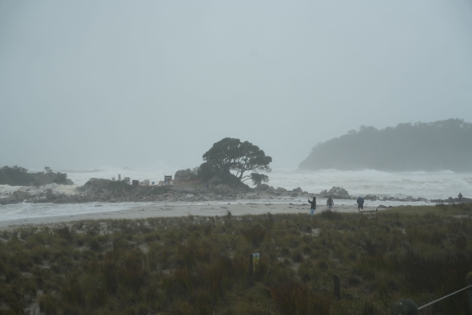
“Cyclone Vaianu is a potentially life‑threatening weather event. Coastal and harbour conditions can change rapidly as the cyclone approaches, making Moturiki Island (Leisure Island) a dangerous place to be.
“We are urging anyone on Moturiki Island to leave immediately and to stay away from coastal and exposed areas.”
Moturiki has been closed for public safety reasons.
“This is not the time for sightseeing or risk‑taking. Closures are in place to protect lives and must be respected,” Wallis said.
10.13am: Rotorua Lakes Council has activated its Emergency Operations Centre.
The council said it was monitoring the forecast and remained in contact with emergency services, contractors and Civil Defence teams across the North Island.
"So far we've had minimal calls about weather-related issues."
The council advised people to stay home and stay safe, and to follow official channels for the latest updates and advice.
There was no State of Emergency in place for Rotorua and no official evacuations had been ordered.
People who felt unsafe were advised to self-evacuate to friends or family in the first instance.
If that was not possible, they could contact the council on 07 348 4199. In an emergency, call 111.
9.24am: A slip is blocking Poripori Rd in Lower Kaimai.
Western Bay of Plenty District Council customer service representative Oceana Butler said the council was notified of the slip between Tebbutt Rd and Crawford Rd about 7am.
“Trees and rocks [are] covering the whole section of the road in both live lanes.”
A member of the public reported getting through via a ditch, but Butler said this was “not a safe option” and the road was closed.
About halfway up Tebbutt Rd, a tree had also fallen across both lanes.
A clean-up crew and traffic management team were on site.
On Omanawa Rd, about 100m from the highway, a tree was blocking one lane, Butler said.
9.15am: Waves exceeding 9m have been detected around Tauranga and Western Bay of Plenty this morning.
The Port of Tauranga's weather and sea conditions monitoring system showed a maximum wave height of 9.1m just before 9am, measured at the A Beacon at sea.
The Bowentown wave buoy has also measured maximum waves exceeding 9m this morning.
This wave buoy is located 7km off Bowentown Heads, north of Tauranga.
The maximum wave height is the largest wave recorded, measured from peak to trough.
The MetService forecasts a northeast swell of 4.5m rising to 7m for a time for the Bay of Plenty this morning.
8.41am: 2degrees says it has cell sites under repair at Apata and Kaimai Lower in the Bay of Plenty.
As of 8am this morning, Chorus had a fibre outage near Maketu.
"We’re currently unable to provide a restoration time," Chorus said.
Chorus's fibre is used by internet retailers including Spark, One NZ and 2degrees.
Chorus also had a fibre outage affecting some properties in Matamata, with an estimated restoration time of 8.15pm.
Tuatahi First Fibre, which provides UFB service in Tauranga, has so far reported no outages.
8.39am: Powerco said as of 7.45am there were about 3400 customers without power in Powerco’s electricity network area.
The most impacted regions were:
- Western Bay of Plenty: About 3000
- Eastern and Southern Waikato: About 200
- Coromandel Peninsula: About 200
According to the Unison outages page there are 837 properties without power in the Tikitere, Lake Okataina, Rotoiti Forest, Okere Falls and Lake Rotoma areas of Rotorua.
8.23am: Whakatāne's Acting Mayor Julie Jukes says Cyclone Vaianu has tracked further east than originally thought overnight, putting her district "directly in the firing line".
Jukes says residents need to take this cyclone seriously and put safety first as it nears. “We are asking residents to follow evacuation advice, stay off the roads unless critical, and to keep well away from the coast. This is not a time to take risks.”
The district is now bracing for gale force winds of up to 150km/h, extremely strong storm surges and potentially 12-metre-high waves when the cyclone coincides with high tide at 2.20pm today.
Whakatāne District Council says this combination represents the "highest risk phase of the cyclone", with conditions expected to be serious, unpredictable and potentially life-threatening.
"While the most severe impacts are anticipated this afternoon, residents need to remain vigilant from now on and be prepared for things to change quickly.
"All mandatory and strongly recommended evacuation orders remain in place. Anyone who has been instructed to leave must stay away from their property until authorities advise it is safe to return."
Duty controller Nicholas Woodley said travel across the district should be limited to emergencies only, particularly during the most intense impacts of the cyclone and high tide.
“Conditions are highly likely to change quickly, given the significant wind and wave height that is forecast.
"We strongly urge people to avoid unnecessary travel and to use inland routes only if they absolutely must move.”
Residents are also being urged not to go to the coast to watch conditions.
“Storm surges and large waves can be extremely dangerous,” Woodley said.
“We don’t want people putting themselves at risk out of curiosity. There are online viewing platforms available for the Whakatāne bar and Ōhope Beach and we strongly encourage the community to use these, rather than go anywhere near the coast in-person.”
People who feel unsafe at any stage are encouraged to self-evacuate inland early and not wait for conditions to deteriorate further. The Whakatāne War Memorial Hall and Rangitihi Marae remain open as evacuation centres for anyone needing a safe place to go.
Jukes said early action was critical, particularly given the likelihood that emergency services may be limited during the most severe weather.
“The most effective things people can do is act early, listen to advice, and look after themselves and each other.”

0 comments
Leave a Comment
You must be logged in to make a comment.