


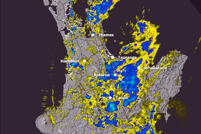
An orange rain warning issued for the Western Bay of Plenty and Rotorua on Tuesday remains in place today.
A strong wind watch is also now in force for Sunday as Cyclone Vaianu approaches New Zealand.
In the 12 hours from 9am today until 9pm, MetService forecasts 60 to 80mm of rain on top of what has already fallen in the region.
The heaviest rain is expected inland, with localised downpours possibly delivering peak rainfall rates of 25 to 40mm an hour. Thunderstorms are also possible.
So far today, 9.5mm of rain has fallen in Tauranga with a total forecast of 48.6mm.
In Rotorua, 17mm of rain has been recorded in the city with a total forecast of 51.2mm expected today.
MetService warned that streams and rivers could rise rapidly, increasing the risk of surface flooding.
Slips were possible, particularly in hill country and rural areas, while driving conditions may become hazardous, especially during heavier downpours.
Western Bay of Plenty District Council said it was actively monitoring conditions and preparing to respond as forecasts for another weather system are refined over the coming days.
Duty controller Peter Watson said council teams were checking known trouble spots, monitoring waterways and reviewing stormwater and roading networks, while staying in close contact with partner agencies.
“As forecasts are refined over the next day or so, our response will continue to be adjusted accordingly,” Watson said.
Given the recent weather events and subsequent rainfall over the last few weeks, Tauranga City Council said there was an increased risk of both new landslides occurring and additional damage at sites where landslides have already occurred.
“If you learn or suspect that a landslide is occurring or is about to occur in your area, evacuate immediately if it is safe to do so,” the council said.
“Seek higher ground outside the path of the landslide. Getting out of the path of a landslide or debris flow path is your best protection.”
It advised people who felt unsafe at their property to self-evacuate to family or friends. “Take animals and any medication you may need.”
Cyclone Vaianu
A strong wind watch has now been issued for the entire North Island, including Bay of Plenty and Rotorua.
The watch is valid for 22 hours from 1am to 11pm Sunday.
Cyclone Vaianu is likely to move across the North Island on Sunday, 12 April 12, the MetService said in its latest weather update.
“If it does, it will bring damaging, potentially life-threatening winds. However, uncertainty remains in the cyclone’s exact track, so the locations of the most severe winds are not yet certain.
“As confidence in the track increases, parts of this watch will be upgraded to orange or possibly red warnings.”
MetService said Vaianu would also bring heavy rain, with heavy rain watches and/or warnings likely to be issued on Thursday for some areas.
Meanwhile, meteorologists in Fiji say they have recorded storm-force wind gusts of up to 185km/h and waves towering more than 8m.
A Fiji Meteorological Service spokesman in Nadi told the Herald the Category 3 storm has sustained winds of 130km/h at its core and 185km/h gusts.
“The last available information showed waves in excess of 8m in the centre and rainfall at more than 50mm and in some places 100mm, in a 24-hour period.
“It’s wreaked quite a lot of havoc ... some of our weather systems are also not working properly because we’ve had power outages, so they need to restart.”
The spokesman believed the worst was over for Fiji.
“There’s barely any possibility of it moving to a Category 4, it’s quietened down.”
All schools across Fiji have closed under a Government-led directive and multiple flights to and from the island have been cancelled.
The handover to MetService would be “later this evening”, he said, when Cyclone Vaianu is expected to reach New Zealand waters.
The latest track of Cyclone Vaianu was projected by the Joint Typhoon Warning Centre.
All eyes are on Northland and the upper North Island as the cyclone is expected to reach the top of the country by Saturday.
MetService reported it was forecast to move southeast across the North Island towards East Cape by midnight Sunday, with the potential for severe gales in Tararua and Manawatū districts.
Giant swells of up to 8m have been forecast from 1am on Sunday, mainly in the east of the Far North, making their way down the east of the country and easing off around Gisborne by Monday afternoon.
Bay of Plenty MP Tom Rutherford said the National Emergency Management Agency and civil defence emergency management groups were monitoring the situation.

1 comment
windy pops
Posted on 08-04-2026 14:23 | By terminal
yeh yeh yeh more of the same gobidly gook
Leave a Comment
You must be logged in to make a comment.