


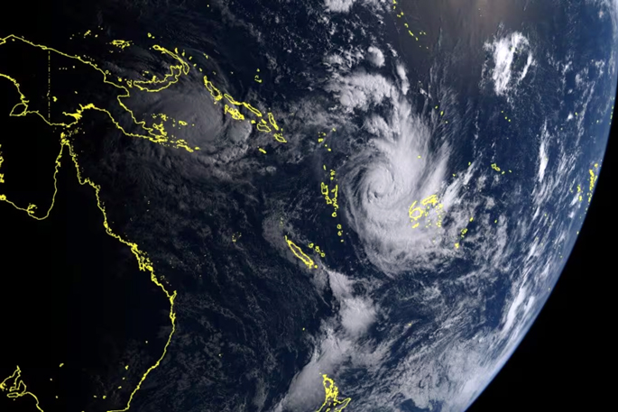
Heavy rain is set to saturate the upper North Island today, raising a fresh risk of flooding in some parts as an intensifying cyclone is making a beeline for Auckland and Northland this weekend.
More than half a dozen watches and warnings are in place for the North Island, including a heavy rain watch for the Bay of Plenty, and top of the South through mid-week, while a separate cyclone is set to “directly hit” Northland and Auckland this weekend.
MetService has issued an orange heavy rain warning for Northland, where up to 120mm of rain could fall before 6pm.
A strong wind watch is in place for Northland, where east to northeast winds could approach severe gale strength in exposed places.
Meanwhile, MetService is also monitoring two tropical cyclones currently active in Pacific waters.
Spokeswoman Heather Keats told Ryan Bridge TODAY cyclone Vaianu currently northwest of Fiji, is set to hit the North Island this weekend.
“We want to make clear this is separate to the current bands of rain the country is experiencing.
“Vaianu is a category two but looks to be upgraded to a category three by this afternoon, possibly even a four... it’s too early to tell.
“When it comes down over Northland and Auckland this weekend it will hold its category two which is highly unusual.”
Meteorologist Paris Marshall said rain was expected to reach the Far North overnight before spreading through the North Island today.
“Streams and rivers may rise rapidly.”
Northland could also see surface flooding, slips and difficult driving conditions, she said.
Residents were advised to clear drains and gutters, avoid low-lying areas and drive cautiously.
 Periods of heavy rain are expected for the upper North Island and the upper South Island. Photo / MetService
Further south, a heavy rain watch has been issued for Auckland north of Papakura, including Great Barrier Island, with rain expected to arrive from around 9am.
The watch also covers the Coromandel Peninsula from midday until 6am tomorrow morning.
In the Bay of Plenty west of Whakatāne, including Rotorua, a heavy rain watch is in place from 3pm until 6pm tomorrow, where rainfall may reach warning levels in some areas.
A separate watch covers the Bay of Plenty east of Whakatāne from 1am Wednesday morning until 11am on Thursday.
The tail end of the weather system is expected to reach the northern South Island later today, with heavier rain forecast for Tasman, particularly northwest of Motueka from 6pm.
Marshall said most of the South Island would escape the worst of the rain, although drizzly and overcast conditions were expected along the east coast, including Canterbury.
Two active tropical cyclones
Vaianu is about 600km northwest of Nadi in Fiji, with Metservice having warned it’s set to make direct impact with the top of the North Island this weekend.
“Vaianu is currently tracking to hit Northland and Auckland. We’re keeping a very close eye on it... it’s still too early to lock in a definitive path.
“It will bring incredibly strong winds, large swells and heavy rain.
“It’s definitely one to be mindful of especially with school holidays.”
Another cyclone Maila, category 3, is currently slow-moving in the Solomon Sea, which Metservice says “won’t have any bearing on New Zealand weather”.
These warnings come after the Northland region recently suffered widespread flooding, with settlements in Whangārei and the Far North cut off and more than 80 homes damaged.
Both districts declared states of emergency following the severe weather.

0 comments
Leave a Comment
You must be logged in to make a comment.