
Tauranga residents are set for a noticeable cool‑down as a cold front moves up the country, bringing colder conditions to mark the start of meteorological autumn.
While much of New Zealand has basked in warm, dry weather in recent days, MetService says a sharp southerly change is on the way – and the Bay of Plenty will not be spared.
MetService meteorologist Surprise Mhlongo said eastern and central parts of the North Island experienced warm temperatures on Thursday, but that was to change quickly as the cold air mass spreads north.
“Parts of the North Island, particularly in the east, were expected to be dry and reach high maximum temperatures on Thursday,” Mhlongo said, noting that places such as Hastings and Napier were forecast to push close to 30C.
“Contrary to these weather conditions, cold air ushered by a band of rain associated with a front is already moving up the South Island.”
What it means for Tauranga
Tauranga is expected to remain mostly dry, holding on to the late‑summer warmth. But by later today, the leading edge of the southerly system will reach the lower North Island, with cooler temperatures predicted to follow into the Bay.
While the heaviest rain was expected in the South Island yesterday – particularly in Westland and the Canterbury Plains – isolated showers and a marked temperature dip are forecast to spread across the North Island today. Thunderstorm activity is also possible for some central and eastern regions this afternoon or evening.
For Tauranga, the more significant shift will be the drop in daytime temperatures as the cold air surges north over the weekend.
Short‑lived calm before another change
Saturday is expected to bring clear, cold and settled conditions across the country as a large high‑pressure system settles over New Zealand. Tauranga is likely to have a crisp, bright day, but overnight temperatures could feel noticeably autumnal.
The calm won’t last long. Another series of rain‑bearing fronts is forecast to move up from the south early on Sunday, reaching the lower North Island by night and spreading further on Monday.
“The arrival of these fronts means a further surge of cold air from the south will spread across the country, with temperatures dropping even lower from early next week,” Mhlongo said. Christchurch and Wellington are both forecast to reach just 14C on Monday, signalling how widespread the cold will be.
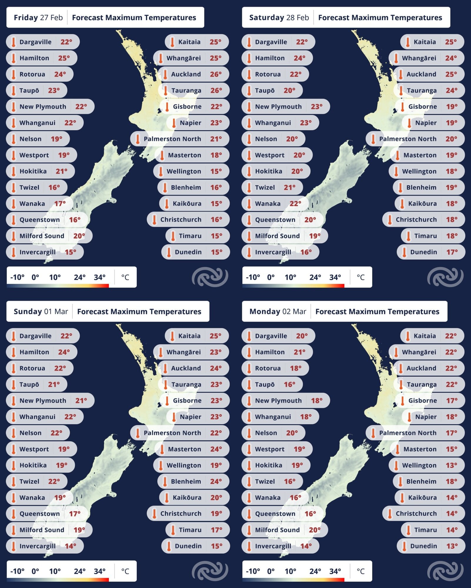
Temperatures are expected to drop around the country over the next few days. Image / MetService
Coldest nights still to come
Clear skies behind the fronts could bring very cold and frosty nights in inland southern areas by Monday night, and while frost is unlikely in Tauranga, overnight temperatures will be significantly cooler than last week.
Autumn may only be beginning, but Tauranga’s long stretch of hot, settled days is about to give way to a much chillier pattern.

0 comments
Leave a Comment
You must be logged in to make a comment.