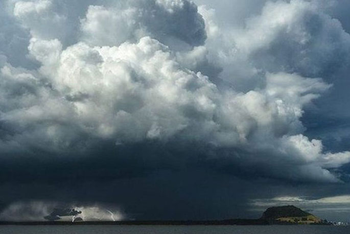
Thunderstorms and downpours are set to drench the North Island from this morning as a tropical low moves in.
Watches and warnings have been issued for much of the island, with heavy rain expected several hours earlier than first forecast.
From 9am a heavy rain watch is in force for Northland, Auckland, Great Barrier Island, the Coromandel Peninsula and down to Waikato and Waitomo - brought forward from the original 12pm. Auckland, Whangārei and Hamilton are currently sitting at a muggy 22C, with forecast highs of 26C.
MetService meteorologist Alwyn Bakker said those watches were brought forward by three hours as the low pressure system got closer and could be pinned down more precisely.
Some heavy rain watches apply for up to 20 hours, with a moderate chance of upgrading to an orange warning.
“It’s not going to be consistently raining over the entire 20 hours - it’s going to be on and off pretty crap, and then at some points during that it’ll be bad enough to warrant the watch,” Bakker said.
Currently the only orange warning is for Bay of Plenty east of Ōpōtiki and Gisborne, coming into force from 6pm and lasting till 10am Saturday, though it could extend further. That warning has only a low chance of being upgraded to a red warning, Bakker said - “still not great but not on the same kind of level as previous events they’ve had there”.
The entire North Island has at least a low risk of thunderstorms, with the risk upgraded to moderate for Northland and northern Auckland this morning, moving south over the course of the day to cover most of the North Island.
Thunderstorms bring a risk of localised downpours, Bakker said.
“Some of these thunderstorms are going to be particularly juicy and there’ll be some really heavy rain associated with them but it shouldn’t last too long for any individual downpour.”
MetService will issue a new thunderstorm forecast mid-morning.
Areas that were hit by heavy downpours a few weeks ago - like Great Barrier Island and the Mahurangi Coast - should be prepared for more heavy rain today, Auckland Emergency Management acting general manager Sarah Le Claire said in a Facebook post.
People should prepare by clearing gutters and drains, Le Claire said. “If you’re in an area prone to flooding or isolation, make sure you’ve got a plan to shelter in place or leave quickly if you need to.”
She also warned people not to drive or walk through floodwaters.
MetService meteorologist Lewis Ferris earlier told the Herald there was a risk of widespread heavy rain across the North Island today.
He pointed to the warm, humid air from the tropics as the cause of the rain.
“Today it links up with a bit more oomph in terms of getting that humid air actually to rise up into the atmosphere and create rain.
“It does bring with it the potential for some very heavy falls, thunderstorms and downpours.”
Tauranga City Council says Adams Ave, between Pilot Bay and the Maunganui Rd roundabout, near the site of last month’s deadly Mount Maunganui landslide, will be temporarily closed to vehicles from 8am today as a heavy rain watch is in place.
The footpath on the ‘shop side’ of Adams Ave will remain open, the council says, adding that the “precautionary approach” follows geotechnical advice about the current risks on Mauao from anticipated rainfall from Friday to Saturday.
“Whilst no definite timeframe can be given for the duration of the closure, it is temporary,” the council said.
“The road will not be opened until the rain event has passed and we have expert advice regarding the safety of the area.”
Weather watches, warnings issued
MetService has issued a series of weather watches and warnings across most of the North Island from this morning until late tonight and early tomorrow.
A heavy rain warning comes into effect for Bay of Plenty east of Ōpōtiki and Gisborne north of Ūawa/Tolaga Bay from 6pm until 10am tomorrow, although heavy rain could continue after that time.
“Expect 80 to 100mm of rain to accumulate, with the chance of 130 to 150mm in one or two places.”
A heavy rain watch has been issued for Northland, Auckland, Aotea Great Barrier Island, the Coromandel Peninsula, Waikato and Waitomo from 9am to 10pm today.
A heavy rain watch begins for the Bay of Plenty, west of Ōpōtiki, at noon. The eastern hill-country of Taranaki, Taupō, Taumarunui, Taihape and Whanganui, as well as Manawatū, the Tararua District and Hawke’s Bay are under a slew of heavy rain watches from this afternoon until Saturday morning.
A heavy rain watch is also set to begin from 9pm until noon tomorrow for Gisborne, south of Tolaga Bay.
“That’s what people are going to need to be aware of,” Ferris said.
“It’s the type of situation where not everywhere is going to get the same amount of rain.
“We could be talking about wildly different numbers town to town, and hopefully we don’t see the same amounts fall on the communities who have dealt with flooding over the last wee while.”
Te Aroha Civil Defence has warned East Coast residents a section of State Highway 35 will close over the weekend.
“Because State Highway 35 remains fragile and to manage safety of our contractors and road users we will be forced to fully close the road from 6pm Friday to 6am Monday 16 February.”
Sign up to The Daily H, a free newsletter curated by our editors and delivered straight to your inbox every weekday.

0 comments
Leave a Comment
You must be logged in to make a comment.