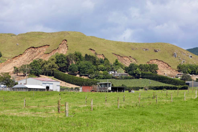
All four homes red-stickered in Tauranga’s Welcome Bay after a deadly landslide last month have had their safety restrictions eased.
The large slip hit neighbouring homes on Welcome Bay Rd, killing two people, during the storm that hit the upper and eastern North Island.
The Western Bay of Plenty District Council said yellow stickers had replaced the red.
“Given the land had dried out since the weather event, and the ‘additional weight’ on the land reduced, council’s consultant geotechnical engineers deemed the risk of imminent slip had reduced to a point where the properties could be accessed, under certain conditions,” it said.
Three homes had a Y2 type of sticker allowing short-term access, and one had a more onerous Y1, which allowed access only to certain parts of a building.
It was up to the homeowners what to do next.
“Additional geotechnical investigations for affected properties will need to be undertaken by the homeowners in conjunction with their insurance companies, to identify a way forward to remove the hazards,” council duty controller Peter Watson said in a statement.
The council was not considering an inquiry, he said.
An independent inquiry is going ahead nearby under the Tauranga City Council into the Mount Maunganui campground landslide that killed six people, and the Government may also do an inquiry.
No detailed survey of landslide risks
The history of landslides in the Welcome Bay area included a geotech study in 1980 that said: “Recent subdivisions in Welcome Bay should be examined by a geotechnical engineer as the area contains many inferred landslides, which may be reactivated by urban development.”
It was titled “A preliminary assessment of geological factors influencing slope stability and landslipping in and around Tauranga city”.
“The site of the fatal slip was not subdivided until the 1990s, with the building having been built in the year 2000, therefore it would not have been one of the subdivisions mentioned in the report,” Watson told RNZ on Tuesday.
The council had not carried out a detailed survey or assessment of landslide risks for the parts of Welcome Bay Rd in the district, he said.
“We instead require that the stability of subdivisions on sloping ground ... is assessed and demonstrated by an accredited geotechnical engineer or geologist as part of the resource consent process.”
Urban and lifestyle development areas that were known to be susceptible to land instability from studies done in 1981 and 2009 became a focus, but the Welcome Bay Rd properties were zoned rural and not included in these studies.
The studies provided input for its district plan hazard maps, covering:
For the latter, “the scale at which this assessment was completed does not allow analysis on a site-by-site or individual subdivision scale”, Watson said.
The Geotechnical Society has a list of geotech studies in the area.
-RNZ

1 comment
Sudden deterioration
Posted on 11-02-2026 22:30 | By Fred Bear
Given the slip damage to this hillscape - it's future is bleak - the old volcanic ash layers are now exposed and the very foundations under the hilltop fort are severely threatened with ever-threatening future slipages. The hill has had its rounded off state for hundreds of thousands of years, yet suddenly it is self destructing in plain sight. During Maori occupation, the hill minus it original forest would have been held together by manuka and its accompanying water absorbent understory of moss and roots. With just very close-grazed grasses now covering the hillsides, it will be interesting to see what remedial actions, if any, "Earth Sciences NZ" can suggest to manage this catastrophic collapse. Would manuka plantings to be the saviour for this historic site since continued grazing is clearly not a long term option?
Leave a Comment
You must be logged in to make a comment.