
A run of the mill front zooms up the West Coast on today, but it's a low-pressure system from the northeast that MetService is monitoring extra closely.
The weather organisation says it has the potential to bring a long period of rain to eastern parts of the North Island from Sunday onwards.
"There is some uncertainty as to where exactly the low-pressure centre will be situated late in the weekend – however there are good indications that this system brings the potential for persistent rain with embedded heavy falls," says MetService meteorologist Lewis Ferris.
"There's a risk that parts of Hawke's Bay and Gisborne will record a month's worth of rain between Sunday and Tuesday, and it potentially doesn't end there.
"This amount of rain would cause disruption and if models keep on the current track, then expert meteorologists at MetService will be issuing Severe Weather forecasts closer to the time."
Strong south to southeast winds are also forecast to accompany the system but these are more dependent on the position and depth of the low pressure centre.
"This is a weather event to keep an eye on developments over the weekend as there is the possibility other regions could be impacted as we move further into next week.
"Before we get there though, to end this week, we have a more typical frontal system move up the West Coast on Friday bringing rain and strong northerly winds.
"The ranges of Westland south of Otira have an Orange Warning for Heavy Rain in force between midday and midnight Friday.
"Watches for Heavy Rain and Strong winds are also in force for surrounding areas. The front hardly makes an impact on the North Island.
"Most places will see some settled weather between now and the end of the weekend."
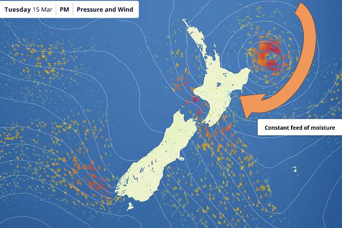 Image: MetService.

0 comments
Leave a Comment
You must be logged in to make a comment.