


After last week's dry and settled weather, MetService is forecasting a wet and wild week for most in the lead up to the Easter long weekend as a humid airmass persists over the country.
However, a cold front on Friday brings relief from the warm nights, followed by more settled weather into the Easter weekend.
A slow-moving front embedded in a warm and moist northerly flow brings periods of rain to the North Island today.
Severe Weather Warnings and Watches have been issued for heavy rain in Northland, Taranaki, Waitomo, Taumarunui, Taupo and Taihape.
These humid conditions are also favourable for thunderstorm development, with much of the northwest of the North Island under a moderate thunderstorm risk.
"A Severe Thunderstorm Watch is in force for Northland and Auckland, with localised downpours possible until 8pm Monday night," says MetService Meteorologist Amy Rossiter.
Meanwhile it's mainly fine over the South Island, however, due to this humid airmass some low cloud persists along the east coast and a few showers develop during the afternoon and evening for inland areas.
A complex low pressure system deepens in the Tasman Sea on Tuesday, before moving over the country on Wednesday and Thursday bringing another dose of rain and possible thunderstorms to many regions.
Further watches and warnings for heavy rain are expected to be issued.
"Areas to keep an eye on include the northwest of the North Island, central NZ and eastern South Island.".
On Friday, a cold front moves swiftly up the country.
This is accompanied by another period of rain with strong southwest winds, and brings relief from the humid nights.
"As we head into the Easter weekend, a ridge builds over the country bringing more settled weather for most.
"The Easter bunny will be pleased."
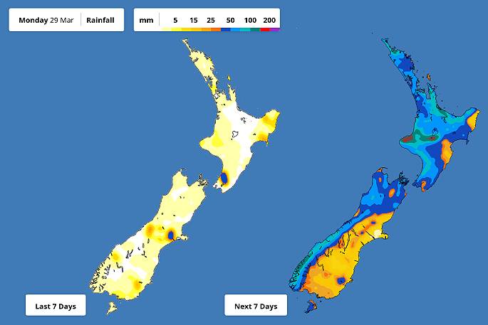 Image: MetService.

0 comments
Leave a Comment
You must be logged in to make a comment.