


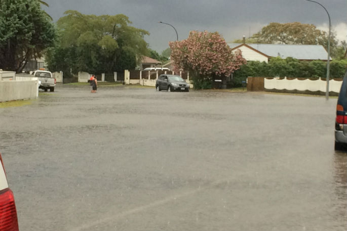
City council staff and contractors had little warning on the intensity of last night's thunderstorm that resulted in surface flooding across parts of the city.
Cameron Road flooded from 15th Avenue through to Greerton, and there were reports of flooding on 21st Avenue, 15th Avenue and Fraser Street.
At Ngatai Road, Bethlehem and the Historic Village, city council rain gauges recorded between 65-70mm of rainfall last night within 90 minutes.
Other parts of the city received up to 25mm of rain in the same period.
But it wasn't until 7.30pm that MetService issued a thunderstorm warning for Tauranga, based on its live radar.
'This meant that the storm was already underway and that there was a higher risk of intense rainfall,” says the city council's emergency manager Paul Baunton.
'When this occurs, we don't get the opportunity to pre-clear drains or ponding hotspots. During the storm, our contractor was very active in responding to areas where flooding was occurring and staff were supporting them. The contact centre increased its staff to manage the additional calls.”
The thunderstorm watch in place during the afternoon was for the North Eastern part of the North Island and didn't give any certainty, apart from stating weather conditions existed that might cause thunder, says Paul.
Council staff continued to monitor MetService weather software during the afternoon and early evening.
It was then estimated the city would receive 4mm of rain between 7-8pm, and a further 7mm between 8-9pm, and the weather radar showed relatively benign conditions for Tauranga.

7 comments
Give us a break
Posted on 19-12-2017 18:02 | By The Sage
The Meterologists have told us we were getting thunderstorms for the last 2 weeks. They had to get it right at some stage.
Not Warned?
Posted on 19-12-2017 18:07 | By Maryfaith
We have been warned about the 'POSSIBILITY' of thunderstorms and heavy rain for the past week. There comes a point that one just ignores the forecasts lately! Like the boy who cried 'wolf' too often - when the wolf did come, no one believed him!
chookymac
Posted on 19-12-2017 18:26 | By Chookymac
Excuses Excuses TCC you should venture into the real world of Business and have to be on you toes 24-7
Hang on a moment
Posted on 19-12-2017 21:27 | By penguin
The Met service had indicated for most of the day that there could be severe thunderstorms for Bay of Plenty and adjacent areas. The map showed a large area of red. While it did not include Tauranga specifically, the notes accompanying the map advised adjacent areas that they could experience severe weather. In the event, we copped a slow moving intense system that was virtually stationery overhead Tauranga and which developed significant energy, ultimately producing what the forecast/watch/warning had indicated.
Wow
Posted on 19-12-2017 21:54 | By Christine1965
Is that how they operate? Pre-clear after an accurate forecast. If in charge I would probably just keep them clear
I thought regular maintenance...
Posted on 20-12-2017 08:06 | By Border Patrol
...of drains and fixing "ponding hotspots" should be part of the councils ongoing works programmes. This is where rates money should be going first, not all of the "nice to have's" the council seem to be so fond of.
Mondays storm.
Posted on 20-12-2017 08:58 | By scottamm
At Parkvale on Monday night we recorded 87 mm of rain in an hour and a half. thats 3 and a half inches in the old term
Leave a Comment
You must be logged in to make a comment.