Expect to need an extra pair of socks this week, as a low pressure system moving over the South Island and parts of central North Island brings snow, wind and rain.
MetService meteorologist Tom Adams says most parts of the country have woken up to good weather.
'It's not a bad morning around the most of the country.
'We had a southerly run up through the country yesterday, so temperatures would have been a bit lower but there's clear skies over much of the North Island.”
Temperatures recorded at Tauranga Airport overnight saw a low of 6.6 degrees, says Tom.
He says the drop in temperature is being caused by a low pressure system, which is expected to affect the South Island and parts of Central North Island later today.
'With this low coming in we're going to see rain coming in across the South Island, starting in Westland shortly and getting heavy from late afternoon.
'Because it is fast-moving nothing really lasts very long. There is a smaller chance of heavy rain in Fuller Island, Nelson, Dunedin, Clutha and other South Island areas.
'Attached to this is a strong weather warning in Canterbury, Marlborough, Wellington and southern Wairarapa, southern Taranaki, Wanganui, Kapiti and Manawatu.
'This is all in those strong north westerlies ahead of this low, which are happening this evening through to early tomorrow. Again quite a short burst but it could make for quite a noisy night.
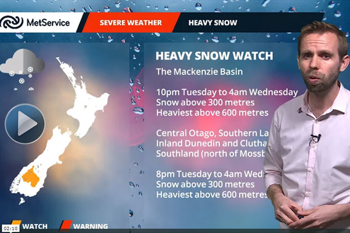
'We also have a watch out for heavy snow in Mackenzie Basin, central Otago, Southern Lakes and inland Dunedin, Clutha, and southwards from Mosgiel.
'We're expecting small blasts of snow of about 400m, from late this evening through to tomorrow morning.”
He says Tauranga will manage to escape a majority of the weather seen down south.
'Tauranga is not under any watches or warnings, and has spared the worst of it but this doesn't mean we won't feel anything.
'Cloud will start increasing this evening and there will be a few showers about.
'At the moment a southerly is passing through Tauranga which will turn northerly overnight, rising to gale northerly by tomorrow.
'This is not severe gale however, severe gale is anything over 90km/h whereas gale is anything above 63km/h. By tomorrow afternoon these gales will be turning southwest.
'There will be some heavy falls possible through the morning, clearing by the afternoon.
'It's a very fast moving system so on Thursday it's looking as if it's pretty much all gone and it could be getting fine again so Tauranga certainly doesn't get the worst of it.”
A severe rain warning has also been issued for the Eastern Bay of Plenty.
"It is only the Eastern Bay of Plenty and the eastern ranges in this area, Tauranga is not included in this area.
"What is happening is the low has a front associated with it and that front is bringing with it some heavy rain.
"Just like everything with this system it's going to be short and sharp, during its passing through the Bay of Plenty you can expect 60-80mm of rain, with peak intensity at 15-20mm per hour."

0 comments
Leave a Comment
You must be logged in to make a comment.