<
A moist northeasterly flow is set to hang around until the end of the weekend, with further bands of heavy rain and thunderstorms forecast to affect the upper North Island.
However, severe weather warnings and watches remain in force.
MetService Meteorologist Peter Little commented says a slow-moving low over the north Tasman Sea is responsible for directing the muggy northeasterlies over the north of the country.
'As well as heavy rain and thunderstorms, folk in the Far North had to endure overnight temperatures of around 20C and near 100 percent humidity.”
This weather situation isn't showing any signs of changing over the next few days, with more bands of heavy rain and thunderstorms forecast for northern New Zealand.

Further south, a ridge of high pressure that is bringing mostly fine weather to the remainder of the country starts to retreat southwards during Friday, allowing the bands of rain to also spread southwards.
'It's looking like it will be wet at times over the weekend across much of the country, so if you've got outdoor plans make sure you keep up to date.”
Keep up to date with the latest forecasts and any watches/warnings at metservice.com or on mobile devices at m.metservice.com.
You can also follow updates on MetService TV, on Facebook, @metservice and @MetServiceWARN on Twitter and at blog.metservice.com
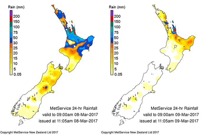 Accumulated daily rainfall recorded to 9am Wednesday and Thursday. Image: MetService.
Keep up to date with the latest forecasts and any watches/warnings at metservice.com or on mobile devices at m.metservice.com.
You can also follow updates on MetService TV, on Facebook, @metservice and @MetServiceWARN on Twitter and at blog.metservice.com

0 comments
Leave a Comment
You must be logged in to make a comment.