


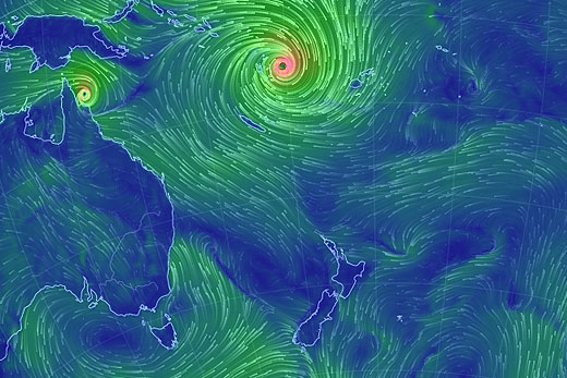
Cyclone Pam has been officially upgraded to a category five storm as it bears down on Vanuatu.
The classification is the strongest in a five-point-scale, with winds of 250km/h or more.
Cyclone Pam is still tracking towards New Zealand with severe weather now expected to hit on Monday. Meanwhile, Cyclone Nathan, sitting at the top of Australia, is heading for Queensland. Image: earth.nullschool.net
Residents in Vanuatu's Torba, Sanma, Penama and Malampa provinces have been put on ‘red alert' by the Vanuatu National Disaster Management Office, meaning they need to seek immediate shelter.
The MetService says a southeast flow should develop over the North Island on Saturday and strengthen on Sunday, as tropical cyclone Pam moves out of the tropics and southeastwards.
TC Pam is expected to remain east of New Zealand, but parts of the North Island are likely to be affected by severe weather on Monday and Tuesday.
The MetService says there is a high confidence of heavy rain and severe southeast gales for Gisborne, northern Hawke's Bay and the eastern ranges of the Bay of Plenty, possibly starting early on Monday morning.
'This risk continues into Tuesday as the low tracks further south and the flow turns southerly,” says a statement from the weather organisation.
'For Northland, northern Auckland and the Coromandel Peninsula, there is moderate confidence that rain could become heavy overnight on Sunday and during Monday, when southeast gales could become severe.”
Southeasterlies are expected to turn southwest as the low tracks further south late on Monday and early Tuesday and there is also a low risk of severe southwest gales on Tuesday.
In addition, strong southeasterlies are likely to affect the remainder of the North Island and there is a moderate confidence that these could become severe around Auckland City, Waikato and the Bay of Plenty, says the MetService.
Winds should turn southwest on Tuesday, and there is low confidence that these southwest gales could also be severe.
There is low confidence of severe south-to-southeast gales for western parts of the North Island from Waitomo and Taupo to Kapiti on Monday and Tuesday.
On Tuesday, as the low tracks further south, there is low confidence of heavy rain and severe southerly gales around Wairarapa and Wellington, and also Marlborough and Canterbury.
The MetService add: 'Also of significance is unusually heavy northerly swell that should affect exposed coastlines from Cape Reinga to East Cape later on Sunday and during Monday.
'As the low tracks south during Tuesday, heavy southeast swell is expected to affect exposed coastlines of Gisborne, Hawke's Bay and Wairarapa.
'This swell has the potential to cause coastal damage and dangerous sea conditions.
'The Chatham Islands are also likely to be affected by gales, heavy rain and unusually heavy swell from later on Monday and during Tuesday.”
There is still considerable uncertainty regarding the track of TC Pam and severe weather watches and warnings will be issued as the situation evolves.
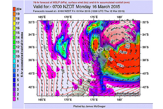
Severe weather is expected to hit the North Island on Monday around 7am as TC Pam sideswipes the country. Image: MetVUW.com

0 comments
Leave a Comment
You must be logged in to make a comment.