


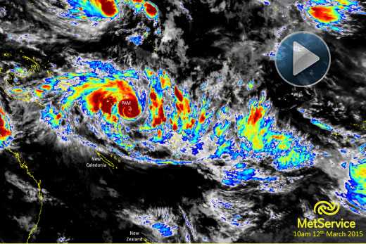
While Tropical Cyclone Pam is predicted to remain to the east of New Zealand, rain and wind is still expected for the Coromandel starting late Sunday.
Severe weather information listed on the MetService's website states the Coromandel can expect heavy amounts of rain and severe southeast gales, with the severity increasing on Monday.
The MetService have stated that Tropical Cyclone Pam has the potential to cause severe weather in the northeast of the North Island. Photo: MetService.
Thames Valley Emergency Operations Manager Gary Talbot says cyclones can cause panic but the best way to combat this is to be prepared and don't take risks.
'Check your property for loose items like trampolines and garden furniture and tie them down,” says Gary. 'Make sure you have plenty of fresh water available and keep up to date with weather forecasts.”
Cyclone Pam is still growing in strength as she passes Vanuatu and New Caledonia and heads towards New Zealand, where the cyclone is expected to pass at an as yet undetermined distance east of East Cape.
Thames Valley Civil defence is keeping in close contact with the duty forecasters at MetService. While warnings are yet to be issued, cyclone Pam is being treated as high priority.
At the moment there is still uncertainty about Pam's course. Tropical cyclones often downgrade to tropical lows by the time they pass New Zealand with wind speeds falling away as they leave the heat of the tropics.
The MetVUW model has Pam passing East Cape with hurricane strength-wind speeds near the eye of the storm.
On Thursday afternoon, Tropical Cyclone Pam is a category four cyclone, expected to be upgraded to five on Friday morning, with winds near the eye rising to around 200km/h.
MetService Meteorologist Peter Little says: 'Tropical Cyclone Pam has the potential to cause severe weather in the northeast of the North Island, where heavy rain, severe southeast gales and large waves are likely from overnight Sunday through to early next week.”
For the latest Severe Weather Outlook, click here.

0 comments
Leave a Comment
You must be logged in to make a comment.