


An isolated intense hail storm in the upper reaches of Whakamarama is a sign of a cold snap that will move over the region this week.
The intense hail storm left the ground white at the Puketoki Reserve, off Leyland Rd, on Monday afternoon as the rest of Tauranga experienced fine weather with intermittent showers.
An isolated hail storm leaves a blanket of white over the Puketoki Reserve on Monday. Photos: Mark Bougen.
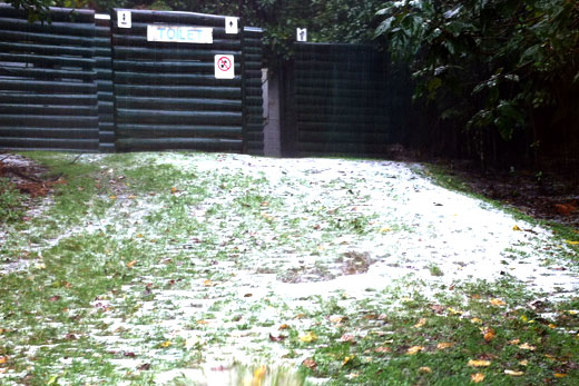
Western Bay of Plenty District Council GIS technician Mark Bougen had headed up the Kaimai Ranges to GPS the tracks of the reserve when he was caught in the intense downpour about 2.30pm.
'We were several hundred metres from the reserve when it started raining, then all of a sudden the rain turned to intense hail.”
The isolated downpour lasted for about five minutes, but was enough to coat a section of the reserve parking in a white sheet.
'It was really isolated, we started heading back to the office and got about a kilometre down the road and it was clear skies. By the time we reached the office it was heavy rain.”
Although he hasn't spent a lot of time in that part of the Kaimai Ranges, Mark says it was rather unusual to experience such an isolated hail storm.
Hail storms also struck Auckland on Monday, leaving a blanket of white in the south-east suburbs. About 2pm a major hailstorm hit Ellerslie causing an office block off Marua Rd to flood, reports NZ Herald.
MetService meteorologist Nicole Ranger says the hail storm was a result of a south-east change that came through Tauranga yesterday afternoon, causing temperatures to drop from 15 to about 12 degrees.
'It was pretty cold temperatures in the upper atmosphere, so the air was fairly unstable causing a bit of hail.
'It's like a thunderstorm; it was colder at the lower levels as well, stopping it from melting before it hits the ground.”
Most of the unstable air was located offshore, and to the west of the Kaimai Ranges touching on the Waikato side, with a small amount in the east.
Nicole says temperatures reached an overnight low of six degrees but further cold weather is expected on Friday and Saturday.
'Looks like it's getting colder – overnight Friday and Saturday temperatures will drop to four degrees. A change of air-mass with a flood of cold air is coming across the country from the south-west, so the whole country will get a bit colder.”
'Tomorrow is mainly fine with brief afternoon showers; then Thursday is cloudy with showers.”

0 comments
Leave a Comment
You must be logged in to make a comment.