


The Ministry of Civil Defence is warning people to prepare for severe weather in the Bay of Plenty this weekend as Cyclone Lusi tracks towards New Zealand.
People are advised to make sure they put away outdoor furniture and secure heavy items with predictions of heavy rain and gale force winds to hit from early Saturday.
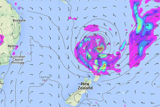
NZ/American rain and air pressure map for 1am Saturday, March, 15.
Currently, Cyclone Lusi is moving away from Vanuatu, where there are media reports of one person being killed as a result of the storm.
Ministry director John Hamilton says they are working with the MetService in monitoring the tropical cyclone as it moves over the Pacific Ocean.
At this stage, John says computer models expect Lusi to arrive over northern New Zealand on Saturday, or early Sunday, heading southwards over the North Island before moving out to sea east of the South Island on Monday.
'Cyclone Lusi is expected to transition into a sub-tropical weather system as it approaches New Zealand, but it is still expected to be a dangerous storm.
'Severe weather is likely to affect many regions during this event, especially over the weekend from Northland down to Canterbury.”
Based on current information, John says adverse weather conditions may be widespread with heavy rain forecast for the northeast of the North Island, from Northland to the Bay of Plenty and north of Gisborne. Heavy rain is also possible for the South Island.
Gale force winds are being predicted for most of the North Island and the upper South Island with severe or damaging gales in some places depending on the track of the low.
John says large coastal waves and storm surges for the northeast of the North Island, especially from Northland to Bay of Plenty, are also expected during the storm.
Winds may strengthen on Saturday afternoon to a 40knt plus easterly, pushing along torrential rain. By 7pm Saturday the eye of the storm is anticipated to be near Great Barrier Island.
The heavy rain is predicted to continue in Tauranga with the wind remaining easterly/south easterly in the 20-25kt range until early Sunday morning when it is expected to strengthen to 25-30knots (30-55kmh) before backing to the north/northeast around daybreak.
John says with winter approaching people should expect storms as part of normal seasonal weather, and all households and work places should be prepared.
'Develop a household emergency plan and assemble and maintain you emergency survival items for your home as well as a portable getaway kit.
'Prepare your property for high winds. Secure large heavy objects or remove any item which can become a deadly or damaging missile.
'Get your roof checked regularly to make sure it is secure. List items that may need to be secured or moved indoors when strong winds are forecast.”
Timing
A rough timing from weatherwatch.co.nz on the storm's path. NB: This is a prediction.
- Sat PM/early Sunday AM the ex-cyclone makes landfall somewhere around Auckland/Northland/Coromandel Peninsula.
- Sunday the centre of the low will track southwards down the North Island. The weather ahead of it - a bit of wind and rain - will move into northern and eastern parts of the South Island.
- Around noon Sunday the centre of the low may be around Taranaki/Wanganui area with severe weather possibly impacting parts of central NZ - however the storm is slowly starting to unwind now.
- Sunday night it will be crossing Wellington in a weaker state - but gales and heavy rain still possible.
- Sunday PM strong winds and rain may also move into Canterbury.
- By noon Monday the storm falls apart almost completely well east of the South Island out in the Pacific Ocean.
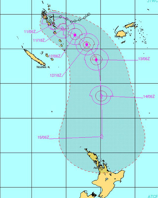 Latest tracking of Cyclone Lusi from JTWC.

6 comments
pffft
Posted on 12-03-2014 12:58 | By rayzgirl
bound to be another NON event, the weather forecast is a bit like the boy who cried wolf
Prepare !!
Posted on 12-03-2014 13:12 | By Moby
All very we'll for these C.D. beaurocrats to say get prepared but you try and find advice from them as to how to get some sandbags to protect from flooding. I rang them all and they were all useless ! No one had any idea ! Tauranga council said if I got flooded to ring them and they would deliver some. Yeah right ,I'd be three feet under water by then especially if it was 2am ! Citycare couldn't help as I'm not in western bay . They can't help tga city residents. Main civil defence also had no idea. Vaguely suggested I get bags from somewhere and fill them but when I suggested from the beach I was told that could lead to prosecution ! Luckily I have found some so I'm ok but best of luck to the rest of you !!
Dammed if you do...
Posted on 12-03-2014 14:07 | By Turk4
Dammed if you don't.... Funny these knockers (tizme) about the forecast. If nothing were said, you would be the first to ask why nothing was said...
Be Prepared is Best Method
Posted on 12-03-2014 15:40 | By Watchdog
We have Tongan friends who have been devastated by at least three significant cyclones and storm the past 4 months. About 70% of their island habitat and crops were destroyed. If this hits as hard as any of those, boy, we will feel it. It is always good to see a storm veer away, but this one is looking pretty determined! We will be putting away all our outdoors bits and pieces - just in case.
For 'tizme'
Posted on 12-03-2014 16:08 | By penguin
So you won't complain if the Metservice is correct and you suffer storm damage????
is
Posted on 12-03-2014 20:40 | By Capt_Kaveman
council out cleaning drains and the st of debris???????????????????
Leave a Comment
You must be logged in to make a comment.