


Roads in the Central Plateau are open again this afternoon with the exception of the Desert Road.
Snow and icy road conditions are forcing authorities to keep the road between Rangipo and Waiouru closed.
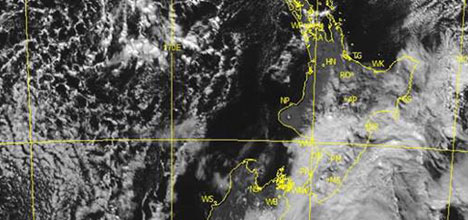
The clouds over the ocean that look like honeycomb are called 'open cell cumulus” and are indicative of the cold Antarctic air moving over warmer oceans. Photo: MetService.
NZ Transport Agency operations manager Karen Boyt says light snow falls with strong winds are continuing on the Desert Road.
She says workers will monitor the situation and the agency should know later this afternoon if the road will be reopened.
'We ask drivers to monitor weather conditions before setting off on their travels.”
The MetService says New Zealand is in the grip of a winter storm, with cold weather drawn up from Antarctica bringing snow, wind and hail.
'This winter storm will have quite a bit of a bark and bite and is expected to bring widespread severe weather for most of New Zealand,” says media and communications meteorologist Dan Corbett.
'While snow will be a major issue for those in the South Island, wind and hail will affect many North Island districts.”
Victoria University of Wellington associate professor James Renwick has researched how polar conditions, like the one the country is experiencing, affect New Zealand's weather.
'To get an event like this, which is pretty extreme, we need the westerly wind that normally blows across New Zealand and the southern oceans to slow down and buckle into a series of big meanders, north-south waves around the hemisphere.
'This is more likely to happen in the negative phase of the Southern Annular Mode (SAM) and we have just gone into negative SAM territory in the past few days.”
He says right now there are a series of large-scale waves around the southern hemisphere, with big southerlies near New Zealand, over the central Pacific, off the eastern South American coast, over the eastern South Atlantic, and over the central Indian Ocean.
'The southerly flow over/near New Zealand is the most impressive as it reaches all the way south to south of 60S.
'The central Indian Ocean southerly is almost as far-reaching. Between all these regions of southerlies, we have regions of northerly winds, east of the Chathams, over the eastern Pacific, over the central South Atlantic, just east of Southern Africa and west of Western Australia. In those areas, temperatures will be much higher than normal for winter.”
He says the air is so cold over New Zealand because the isobars are going all the way around the 65S, which is almost down to the edge of the sea ice at this time of year.
'Hence, we have air coming from a long way south, flowing up over the country, meeting up with warmer, moister air as it comes north, and picking up moisture from the underlying ocean as well.”

0 comments
Leave a Comment
You must be logged in to make a comment.