


Heavy rain and thunderstorms could hit the Bay of Plenty this evening as a narrow front moves across the North Island.
A thunderstorm watch issued by the MetService yesterday afternoon remains in place today. MetService is also warning of possible tornados in the Western Bay of Plenty.
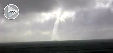
A large waterspout recorded off Papamoa Beach in 2009.
Callers to 0800 SunLive today report seeing a waterspout forming near Astrolabe Reef heading towards Motiti Island around 10am.
This follows two waterspouts that formed over Manukau Harbour in Auckland yesterday.
Weatherwatch.co.nz head weather analyst Phillip Duncan says conditions this week are similar to times when other tornados and waterspouts have formed.
'While there's generally a fairly moderate risk of a tornado forming today, the risk of one hitting your home is still very low.
'The safest thing you can do is simply keep an eye on the sky and get into a small room, like a closet, should you be unfortunate enough to be in the path of a tornado or major thunderstorm.”
Civil Defence says around 20 to 30 tornadoes are seen in New Zealand each year, most on a small scale and in rural areas where they are captured on camera.
'We have pockets of severe weather yesterday and today. For most part people will have a downpour and a rumble of thunder and that's about it,” says Phillip.
'But there will be pockets of more severe weather which could see flash flooding, hail and small scare tornadoes.”
As of 11:50am the Lightning Tracker was showing thunder activity hugging western parts of the North Island.
Send your weather related photos to [email protected]
Or call 0800 SUNLIVE with your weather related news tips.

0 comments
Leave a Comment
You must be logged in to make a comment.