


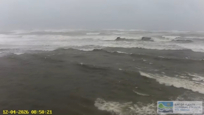
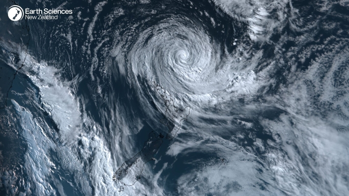
- Cyclone Vaianu is set to make landfall today, with MetService calling it a “multi-hazard, potentially life-threatening event”.
- Bay of Plenty is now under a red strong wind warning and an orange heavy rain warning.
- Tauranga and Western Bay residents living in coastal and low-lying areas are told to seriously consider self-evacuating.
- Thousands of people are without power in BoP
- A local state of emergency has been declared in multiple areas including Tauranga, Western Bay of Plenty, Whakatāne and Waikato including Coromandel.
- Otūmoetai, Matua, Bureta
- Maungatapu (slips)
- Chapel St
- Marine Parade, Oceanbeach Rd, Motiti Rd, Omanu Beach, Harrisons Cut and Taylor Reserve.
- Hungahungatoroa Marae at 24 Hungahungatoroa Rd, Matapihi, Mount Maunganui. Open now.
- Huria Marae at 1 Te Kaponga St, Brookfield, Tauranga. Open from 6pm Saturday. Park on the street.
- Mangatawa Marae at 42 Tareha Lane, Mangatawa. Open from 6pm Saturday.
- Wairoa Marae at 2328 State Highway 2 (Waihi Rd) in Bethlehem.
- On arrival, please register with a marae volunteer on site.
- Please avoid bringing pets. If this isn’t possible, domestic pets are the owner’s responsibility and must stay in vehicles.
- Bring your own blanket and pillow.
- Bring your grab bag containing personal items such as medication, a torch, chargers and personal and sanitary supplies.
- Bring snacks and some food, particularly if you have allergies or require gluten or dairy‑free options.
- Please be respectful of the marae, marae volunteers and others using the space.
- Waihī Beach RSA, 99 Beach Rd
- Katikati Baptist Church, 2 Wedgewood St
- Pukehina Community Hall, 16 Pukehina Parade
- Te Puke War Memorial Hall, 130 Jellicoe St
- Ōmokoroa Pavilion, 28 Western Ave
- The MGC in Maketū, Arawa Ave.
- Tuapiro Marae, Hikurangi Rd, Katikati (open from 4pm on Saturday)
- Paparoa Marae, Borell Rd, Te Puna (will open if needed)
- Whetu Marae, Welcome Bay Rd (will open if needed)
- Makahae Marae, Te Kaika Rd West, Te Puke (will open if needed)
- Pukehina Marae, 2655 State Highway 2, Pukehina (will open if needed)
Those living in low-lying and coastal areas around Tauranga are being told to consider self-evacuating now with a threat of flooding when Cyclone Vaianu crosses the region.
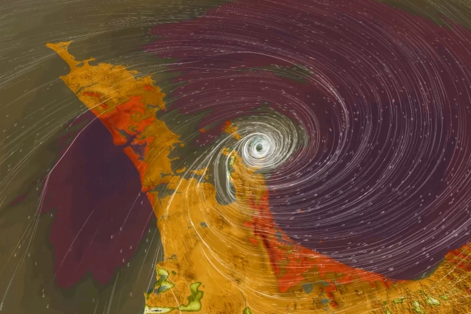
Tauranga City Council is warning the most dangerous period of Cyclone Vaianu is expected around 2pm today when the centre of the cyclone will be across Tauranga as the same time as high tide.
The council says once flooding begins, roads may become unsafe or impassable very fast.
“Act quickly to self-evacuate if you feel unsafe. Tauranga residents living in coastal and low-lying areas that have flooded before should seriously consider self-evacuating now.”
The council said If self-evacuating, to seek refuge with friends or whānau first.
Several marae were open to provide shelter and support, an evacuation centre was open at Whakamarama Hall, and further evacuation centres would open at Mercury Baypark at 8am and Matua Bowling Club at 9am.
The council said based on the current MetService warnings, strong winds were set to continue until 8pm today, with damaging gusts of up to 130km/h possible in exposed areas.
“This level of wind poses a serious risk to life from flying debris and falling trees and creates dangerous driving conditions. Destructive winds can cause widespread damage, including to powerlines and roofs, and may lead to power and communication outages.
 “There are already some parts of the city without power. Prepare now for possible power outages by charging devices, keeping phone use to a minimum, and thinking ahead about how you would manage if power or communications were disrupted.”
Residents were told to avoid unnecessary travel, stay informed through official updates, and take care of friends and whānau.
Powerco said as of 7.45am there were about 3400 customers without power in Powerco’s electricity network area with around 3000 of those in the Western Bay of Plenty.
According to the Unison outages page there are 837 properties without power in the Tikitere, Lake Okataina, Rotoiti Forest, Okere Falls and Lake Rotoma areas of Rotorua.
Tauranga Mayor Mahé Drysdale declared a state of local emergency for Tauranga on Saturday.
States of emergency have also been declared in the Western Bay of Plenty, Whakatāne and Waikato, including Coromandel.
Tauranga City Council said in a statement the declaration allowed the response to worsening weather conditions to be swift and coordinated, helping to minimise the risk to people and property.
“This precautionary step ensures controllers and others with emergency powers can respond quickly and efficiently to keep people safe.
“These powers include the ability to close roads or public places, carry out urgent works, remove or secure dangerous structures and materials, and provide first aid, food, or shelter where needed.
Drysdale said the decision to declare a Local State of Emergency was about giving emergency services extra powers to act quickly, if required, to keep people safe.
“Declaring early is a precautionary measure,” he said.
“Our Emergency Operations Centre is active and ready to respond as needed to support Tauranga throughout this event.
“We are encouraging people who live in coastal or low-lying properties, particularly those that are known to have flooded before, to take this situation seriously and consider self-evacuating early.
“Please continue to follow official updates, look out for one another, and check on neighbours who may need support.”
And hundreds of residents in low-lying flood-prone or coastal areas of Tauranga and Western Bay are being urged to evacuate early, as concerns of a potentially unprecedented storm surge grow.
Whakatāne ordered people in Ōhope’s West End to evacuate by 5pm today.
An emergency mobile alert for a Civil Defence Red Warning has been sent to phones in coastal areas of the Bay of Plenty this afternoon, warning of cyclone impacts from 6pm.
It said there could be life-threatening high winds, falling trees, dangerous river conditions, landslides and flooding.
Large waves, high tides and coastal flooding were also a significant risk.
People were urged to be prepared, put safety first, avoid the coast and self-evacuate if they see rising water or feel at risk of a landslide.
The MetService strong wind warning for the Bay of Plenty tomorrow has been upgraded to red - the highest level - while the heavy rain warning remains orange.
Western BOP state of emergency
The Western Bay joins several other North Island areas in the cyclone’s path in declaring a state of emergency.
Western Bay of Plenty Mayor James Denyer said it was a precautionary step to ensure the district was ready to respond quickly and effectively if needed.
It would assist with co-ordinating resources, supporting evacuations if needed, closing roads or other areas, and protecting people and property.
“Declaring ahead of impact allows us to stay ahead of the situation, rather than forcing decisions to be made under pressure.”
Denyer said significant efforts were being made across the district to help people prepare for the storm and he thanked those involved.
He urged residents to continue preparing, follow official advice, avoid unnecessary travel and stay clear of coastal areas during the storm.
“Please take this event seriously. Preparation is essential and it is far better to be safe than sorry.”
Coastal inundation fears
The Western Bay council yesterday urged coastal residents of Maketū, Pukehina and Waihī Beach to consider evacuating before the storm hit.
Today, Tauranga City Council said residents of hundreds of properties in the city may also be at risk.
The council said coastal and harbour inundation is a “significant and immediate concern” for Tauranga.
There was “potential for flooding at levels not previously seen”, particularly around the 2pm high tide on Sunday.
“People who live in properties on the coast or in low-lying areas that are known to have flooded before should seriously consider self-evacuating early.”
Areas of concern included:
About 800 properties were at high risk of coastal and harbour flooding, with another 200 at risk from coastal erosion.
This included properties along the Mount Maunganui and Pāpāmoa Beach coastline, where sand dune breaches could undermine buildings.
The council said roads may become unsafe or impassable quickly once inundation begins.
“Waiting until water is rising may put people at risk of becoming trapped.”
The council said the cyclone was expected to impact Tauranga from 11pm Saturday, bringing damaging winds, heavy rain, storm surge, high sea levels, and coastal flooding and erosion.
Coastal flooding in the dark or at night would make it harder to see dangers. Fast-moving water can knock people over, sweep away vehicles and cause serious injury or death.
Residents living in coastal and low-lying areas that have flooded before were urged to act early and move to higher ground before conditions deteriorate.
Dangerous coastal conditions could continue even if the cyclone weakened on its approach to New Zealand.
People can check risks in their area on the council’s coastal inundation map.
Tauranga City Council today activated its Emergency Operations Centre.
The council said this meant it had a dedicated team actively monitoring the situation and ready to respond to any emerging issues.
Meanwhile, the council this afternoon said it was extremely concerned by reports of people breaching the closure of Moturiki Island.
Emergency Operations Center Controller Gareth Wallis said this behaviour was putting lives at serious risk.
“Cyclone Vaianu is a potentially life‑threatening weather event. Coastal and harbour conditions can change rapidly as the cyclone approaches, making Moturiki Island (Leisure Island) a dangerous place to be.
“We are urging anyone on Moturiki Island to leave immediately and to stay away from coastal and exposed areas.”
Moturiki was closed for public safety reasons.
“This is not the time for sightseeing or risk‑taking. Closures are in place to protect lives and must be respected,” he said.
BOP forecast
Strong wind warning – Red
The Bay of Plenty and Rotorua are under a 16-hour MetService red warning for strong wind, from 4am-8pm on Sunday.
Severe gale easterlies are expected to change to severe gale northwesterlies Sunday afternoon, with damaging gusts of 130km/h in exposed places.
MetService said there could be a threat to life from flying items and falling trees. Destructive winds will cause widespread damage, including to powerlines and roofs, with dangerous driving conditions and significant disruption to transport and power supply.
It advised people to stay indoors or seek sturdy shelter away from trees, avoid travel, and be ready for power and communication outages.
Heavy rain warning – Orange
The Coromandel Peninsula, and Bay of Plenty west of Whakatāne including Rotorua, are under a 17-hour orange heavy rain warning from 11pm today to 4pm Sunday.
MetService said to expect 120 to 150mm to accumulate, especially about the ranges. Peak intensities may reach 25-40mm/h in downpours on Sunday morning and afternoon.
Large swells and coastal inundation are likely, and streams and rivers may rise rapidly.
Surface flooding, slips and difficult driving conditions are possible.
People were advised to clear their drains and gutters, avoid low-lying areas and drive cautiously.
Where evacuees should go
People are urged to see if friends or family will take them in as a first option.
Tauranga
Emergency Assistance Centre
Mercury Baypark will open from 8am on Sunday at 81 Truman Lane, Mount Maunganui.
Marae
Important information:
Western Bay of Plenty
Community emergency hubs would be opening across the district on Sunday.
Community emergency hubs
Marae

2 comments
Over reaching
Posted on 11-04-2026 19:40 | By ShaneS
As per usual the local government is overreacting to the overactive weather reports we get and start panic buying at supermarkets, I was at the supermarket earlier today and everything is cleaned out, what are people thinking. The panic buying of water etc is just dumb and plain stupidity, it’s 7.31 with very little wind and as I track the once was tropical storm it’s getting less intensive.
I have said and will say again, I have lived in Tauranga for 65 years and there has always been rain and wind at times, it’s nothing new. I also blame the over reporting of possible events when you should concentrate on what has happened and forget the crystal ball gazing.
@ ShaneS
Posted on 12-04-2026 15:04 | By Yadick
It's a no win situation.
They're damned if they do and damned if they don't. In my opinion it is better to be proactive (not dramatic) in these situations than to minimize. I think they've done well.
Leave a Comment
You must be logged in to make a comment.