


1pm update:
A state of emergency has also been declared in Whakatāne with some Ōhope residents ordered to evacuate by 5pm today.
It was declared for Whakatāne District at 8.55am today by acting Mayor Julie Jukes.
Jukes said the declaration was in response to the expected impacts of Cyclone Vaianu, with properties along West End, Ōhope ordered to evacuate by 5pm today.
Forecasts indicated dangerous coastal conditions, including the risk of landslides, storm surge, large waves and coastal flooding.
“Declaring a State of Local Emergency means we have every tool available to us to protect our communities. We're not waiting for conditions to worsen - we're acting now while we still have the advantage of time.”
A mandatory evacuation order now applies to all homes in West End Ōhope, up to and including Beach Point Apartment complex.
“Protecting lives is our absolute priority. Those in West End, please leave now, while it is safe to do so.”
Local controller Nicholas Woodley said council staff and police would commence door-knocking affected properties shortly.
“Don't panic, go early - there is still time to move safely”.
Residents were asked to prepare for two days away from home and would have until 5pm this evening to relocate. Following this, a police-managed roadblock would be in place at the start of West End. Re-entry would be reassessed at daylight on Monday,.
Woodley said the message to the West End community was simple.
"Pack what you need, tell your neighbours, and go. There is no need for panic - but there is every reason to move now, while the roads are clear and conditions are manageable."
In addition, Woodley strongly recommended residents of other properties in Ōhope that are exposed to landslides, storm surge or coastal inundation self-evacuate to friends and family further inland as soon as possible.
"We have concerns for beachfront properties on Pōhutukawa Avenue, Waterford Estate and Plantation Reserve, and low-lying properties near Ōhiwa Harbour such as Liddon Cove, Ōhiwa Parade, and Harbour Road."
Four regions across the North Island have now declared a state of emergency as Cyclone Vaianu nears.
A local state of emergency has been declared for Hawke's Bay, including Hastings and Napier. Targeted beachfront evacuations are expected to begin this afternoon.
A Regional State of Emergency has been declared across the Waikato region, including the Coromandel, as authorities brace for the full impact of Tropical Cyclone Vaianu on Sunday.
Thames-Coromandel District Council's Brian Carter said the move would allow a faster, more coordinated response.
He said the step allowed authorities to mobilise resources faster and support communities more effectively as conditions worsened.
It also gives emergency services and local authorities extra powers to respond quickly as severe weather approaches, with orange and red warnings already in place.
He said widespread impacts had been expected across the district, and the declaration ensured officials could act decisively.
Officials warned Cyclone Vaianu remained a multi-hazard, potentially life-threatening event, with damaging winds, heavy rain, large swells and coastal inundation expected from late Saturday and continuing through Sunday.
Civil Defence emergency centres were being activated across the district, with residents encouraged to check official channels for locations and updates.
People were urged to complete preparations to reduce risks to property, health and wellbeing.
Sandbags remained available at collection points in Whitianga, Thames, Whangamatā, Coromandel Town, Tairua and Pāuanui.
Authorities advised those in low-lying coastal areas, including campers, to move to higher ground. Some freedom camping sites had already been closed, with more closures expected.
Residents were also told to secure outdoor items, check on neighbours and whānau, and ensure they had enough supplies and charged devices to last several days.
People were warned to stay away from beaches, wharves, jetties and other coastal structures as conditions deteriorated.
Officials said further updates would be issued as the situation developed, urging people to continue monitoring MetService forecasts, council channels and local radio.
Tauranga City Council has activated its Emergency Operations Centre ahead of the arrival of Cyclone Vaianu. The council said this meant it had a dedicated team actively monitoring the situation and ready to respond to any emerging issues.
Earlier story:
A relatively calm morning across the North Island is the perfect time to get prepared and make a plan before severe weather brought by Cyclone Vaianu hits this evening.
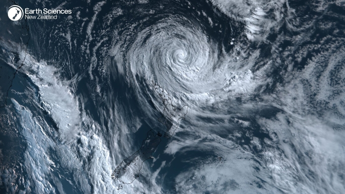
Multiple rain and wind warnings are in place for later today, with Cyclone Vaianu moving southwards towards New Zealand as a significant sub-tropical system – what MetService has labelled a “multi-hazard, potentially life-threatening event”.
Meteorologist Alanna Burrows said rain and wind will start to develop throughout the day in the North Island, becoming “more persistent” in the evening.

One rare red and 22 orange rain and wind alerts have been issued across the North Island as Cyclone Vaianu approaches New Zealand. Video / MetService
“We’re going to start to see some of that rain developing through Saturday for the North Island and also a strengthening of easterly to southeasterly winds,” Burrows told the Herald.
“That rain’s going to approach from the north and then gradually through the day it’s going to become more persistent in the evening and heavy for Northland, Great Barrier Island and the Coromandel Peninsula, as well as starting to see quite widespread rain across most of the North Island all the way down to places like Taihape and also Hawke’s Bay.
“And then that rain will become more widespread again through Sunday and heavier for everyone.”

What to pack in an emergency.
An orange strong wind warning is in place for Auckland from 9pm on Saturday until 4pm Sunday, with severe gales up to 130km/h expected in exposed places. There is a moderate chance (30-60%) of it being upgraded to a red warning.
Orange heavy rain and strong wind warnings have also been issued for Northland today from 9pm and 11pm respectively, with a state of emergency already declared in the region.
On Sunday, when Cyclone Vaianu is expected to make landfall, all of the North Island is under either a heavy rain watch, strong wind warning or heavy rain warning, with the Coromandel Peninsula and Great Barrier Island expected to be hit with damaging gusts of 140km/h causing flying items and falling trees.
“The widespread impacts associated with this system, even far from the centre, we’re expecting some very dangerous winds and possibly life-threatening,” Burrows said.
“The winds are changing direction because this system is circulating round going clockwise around this low centre. Originally you’ve got some severe gales coming from the east and then they’re going to turn and start to come from the west. It’s going to be hit by both sides as well as quite widespread torrential heavy rain too.”
For those who haven’t already prepared their homes and made a plan for the severe weather, Burrows said this morning is “definitely” a good time to do so.
“We would like people to act now to get prepared and be ready for the event coming. So they have been lucky with this fairly settled weather window beforehand. People can use the time wisely to be ready for when this comes through.”
Burrows also warned of “very hazardous coastal conditions” during the event, with people advised to stay away from the coast and keep in touch with marine forecasts.
“There’s some large coastal waves expected with this event. So we’ve got a building northeasterly swell coming to New Zealand and that should be peaking on Sunday for the northeastern coastlines of the North Island.
“They could see swell waves reaching 6-8m. And then on top of that we’ve got waves created by the wind that’s associated [with the event].
“As that low moves along there’s a storm surge of possibly half a metre too. So very hazardous coastal conditions. We recommend staying away from the coast, but if you are a mariner or something, keep in touch with the marine forecast and the warnings.”

0 comments
Leave a Comment
You must be logged in to make a comment.