Tauranga may get the tail end of the Tropical cyclone Evan, currently hammering Fiji after causing destruction in Samoa, this week.
WeatherWatch.co.nz is predicting a 60 per cent chance of Cyclone Evan travelling towards the upper North Island – an increase from the 20 per cent chance forecasted last week.
Cyclone Evan is hammering Fiji with 3500 people evacuated. Photo: Seti Afoa.
Head weather analyst Philip Duncan predicts the tropical storm will drop south towards Northland, Auckland, Coromandel Peninsula, Waikato, Bay of Plenty and East Cape this weekend.
'In what shape or form is yet to be worked out but even as an ex-tropical cyclone Evan could still bring flooding rains and damaging wind gusts.
'We aren't going to be hit in the same way as Fiji is, but we can't rule out a day or two of severe weather for some parts of New Zealand this coming weekend as Evan likely moves down our way.”
Philip says the models show Evan will be weakening before he reaches New Zealand and will most likely fizzle out around the nation.
'Cyclone predictions for New Zealand are always very hard - look how narrow the top of New Zealand is - these storms can slide down either side like an egg on a roof.”
There is no need to panic, but people should monitor the weather forecasts and latest weather news as cyclones and ex-cyclones can be fairly unpredictable, he says.
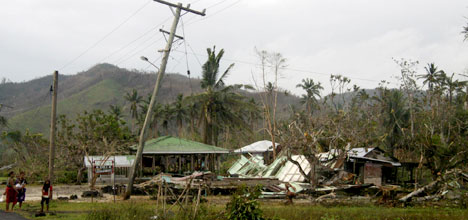
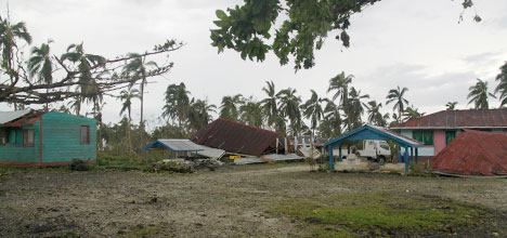
Fiji is today being battered by the cyclone – with winds of about 170km/h likely to continue for the next 12 – 24 hours.
The Fiji Ministry of Information reports more than 3500 people are in evacuation centres.
Commissioner Western Commander Joeli Cawaki confirmed at 11am today at 10 centres were open however official figures of those in these centres have yet to be confirmed as people continue to arrive in numbers.
Without Cyclone Evan, Christmas Day's weather would be settled for 90 per cent of New Zealand, says Philip.
'This deadly tropical cyclone will be catastrophic for some communities and low lying islands. This is about as serious as it gets.
'Now we have a bit of a wild card.”

1 comment
.
Posted on 20-12-2012 08:29 | By Capt_Kaveman
very unlikely now we have a NW system flowing into the tasman and the x TC is colapsed and heading SE may get some rain from either system but that be about it
Leave a Comment
You must be logged in to make a comment.