Weather authorities keeping a close eye on Tropical Cyclone Gabrielle says it is looking more likely that New Zealand will be directly affected.
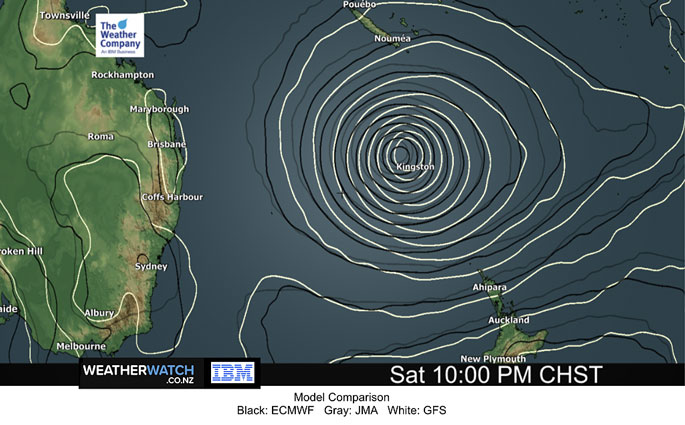
Global computer models continue to remain very aligned as far as tracking, timing and strength of Tropical Cyclone Gabrielle as it reaches New Zealand this Sunday to Tuesday, says the latest update from WeatherWatch.co.nz
"Whilst no official warnings are yet locked in this far in advance, the data this morning means the likelihood of severe weather across much of the North Island looks highly likely," says a spokesperson for the weather organisation.
"If this current modelling comes true, this will likely be the most serious storm to impact New Zealand this century - especially with Auckland being in the mix for a potential direct hit.
"The South Island isn't immune either - the upper South Island has a chance of heavy rain around Kaikoura and gales."
WeatherWatch says the storm will be tracking South-East out of the tropics, likely as a Severe Category 3 cyclone this weekend, and will become extra-tropical at some point.
This process changes the structure of the storm and can temporarily weaken it, before deepening occurs again, says WeatherWatch.co.nz head forecaster Philip Duncan.
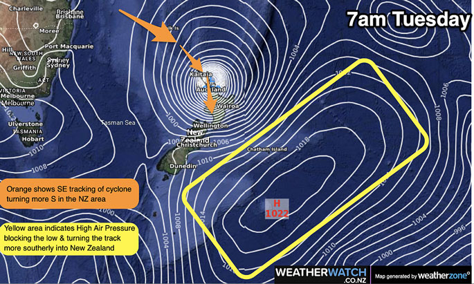
"Just as Gabrielle reaches northern NZ it's expected to encounter higher air pressure to our east - this acts like an invisible brick wall in the sky and that is expected to then curve the cyclone due-south and directly into the upper North Island.
"This is an extremely concerning set-up and all North Islanders - and some in the South Island - need to be well aware of this storm's path and potential severe weather.
"Not only has the modelling been very consistent in the past 48 hours, but the angle this storm is tracking in from already means northern NZ would naturally be at a higher risk."
EXTREMES:
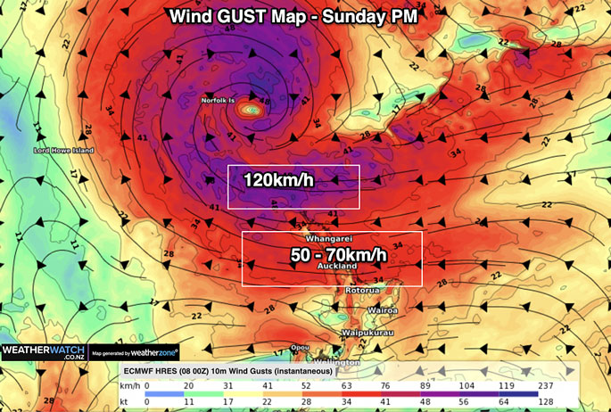
- Winds: Generally speaking winds in the most extreme cases will be 120 to 150km/h, maybe higher - peaking later Monday and early Tuesday from the east, before swinging around from the west.
- Rain: 200 to 300mm, with some ranges in the North Island potentially in the 300mm+ range. Check your WeatherWatch.co.nz or RuralWeather.co.nz forecast for your current general local rainfall estimates.
- MetService will likely issue warnings in the coming day or two.
TIMELINE:
- Sunday - Easterlies ramp up with gales developing from Auckland northwards. Some rain developing.
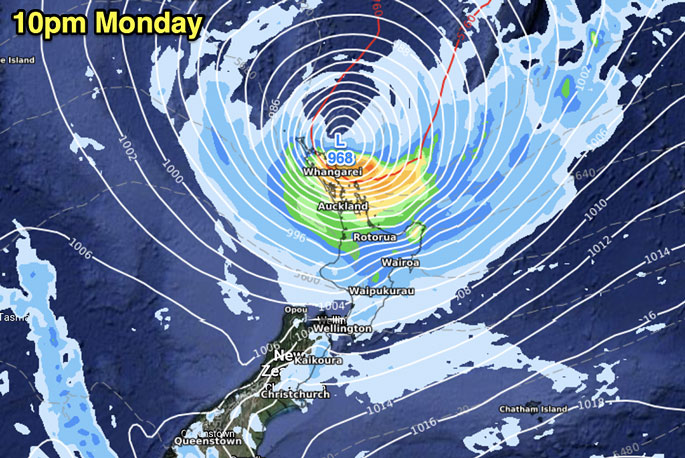
- Monday - The centre of the cyclone moves in to northern NZ late in the day and overnight. Peak damaging winds and heaviest rain expected across Monday and into Tuesday.
- Tuesday - The cyclone moves down the North Island
- Wednesday - Conditions slowly easing across NZ but gales and some rain still lingering.
COULD THIS STILL CHANGE?
"As we keep saying, this isn't 100 per cent yet locked in - but with each day that goes by and the modelling doesn't change, it increases confidence," says Philip.
"If that blocking high changes shape it could allow the storm to move through faster or slightly further north.
"This hasn't been the case in the global modelling for nearly three days now, but that would be the main area forecasters would be looking at for any changes to the current NZ forecast and tracking.
"We expect the path to be locked in by Friday... or Saturday morning at the very latest. Once the path is locked in, severe weather warnings are most likely."
To make more sense of peak wind and rain - please check the rain and wind graphs (also hourly air pressure) at RuralWeather.co.nz - it covers all city suburbs too.
THE MAPS...
size=2 width="100%" align=center> size=2 width="100%" align=center>
WIND GUST MAPS...

4 comments
Great
Posted on 09-02-2023 11:03 | By Yadick
We're so overdue for a bit of rain. I would hope that when this drought finally breaks that TCC will address the water restrictions or better still FIX THE PROBLEM properly without bandaids.
How about...
Posted on 09-02-2023 13:46 | By morepork
... if we all chant:"Rain, rain, go away! Come again another day!"?
@ morepork
Posted on 09-02-2023 14:49 | By Yadick
Cause then it'll be like PM Hipkins/Labor. Just stalling so it all looks good but pick it up further down the track. Unfortunately these wet, hot windy storms are a lot like Commissioners. They're going to do there own thing regardless and who knows what's next. Some parts are good and some parts are disastrous.
@Yadick
Posted on 10-02-2023 11:38 | By morepork
LOL! Thanks for a spot-on response.
Leave a Comment
You must be logged in to make a comment.