UPDATE 6.56pm: The section of SH25 stretching from the SH25A intersection to Tairua is now reopen.
"Thank you for your patience," says a Waka Kotahi spokesperson.
UPDATE 6:15PM
— Waka Kotahi NZTA Waikato/BoP (@WakaKotahiWaiBP) January 5, 2023
This section of #SH25 is now OPEN. Thank you for your patience. ^CO https://t.co/iSCgoIqY9t
Although this section of the highway is now open, SH25 east of Coromandel remains closed due to a "secondary slip" according to a social media post by Waka Kotahi on Twitter.
FINAL UPDATE - 6:50PM#SH25 east of Coromandel remains CLOSED due to a secondary slip. For further up-to-date information this evening please check our website at: https://t.co/TRLU3Q5CvH ^CO https://t.co/p1Vim4xKiS
— Waka Kotahi NZTA Waikato/BoP (@WakaKotahiWaiBP) January 5, 2023
EARLIER 1.16pm: The Mount Maunganui lifeguard service is scrapping a flagged patrol area today due to the weather, and have raised a "dangerous swimming conditions" flag.
This means "swimming and water activities are not advised to keep everyone safe," according to a Facebook post by the lifeguard service.
"Our lifeguards will be roaming along the beach in vehicles - so if you see anyone in difficulty, in the water; dial 111 so our lifeguards can respond," the post reads.
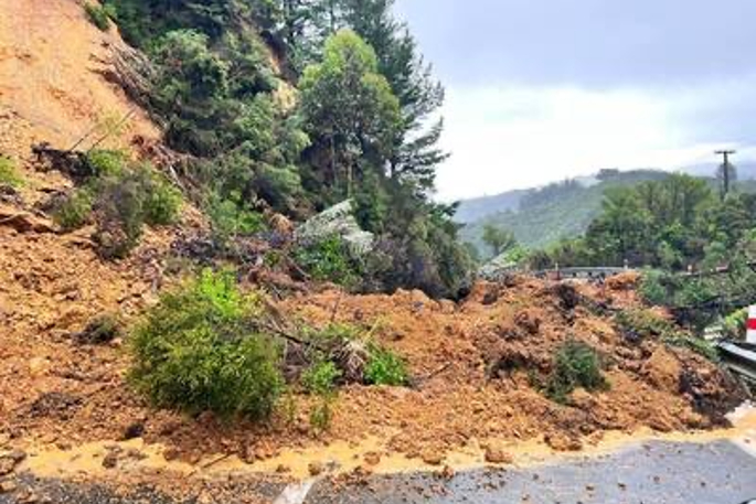
A slip south of Papa Aroha Holiday Park. Photo: Katherine Sullivan Shepherd.
EARLIER 11.19am: A Coromandel motorist says 309 Road is closed by a slip "at the Coromandel town end" of the road.
"There is a tree down and a slip south of Papa Aroha Holiday Park," the motorist adds.
EARLIER 10.48am: State Highway 25 is the latest road to close due to flooding following wet weather.
The highway is closed between Wade Road, Whitianga and 309 Road, Kaimarama.
"Delay your journey or allow extra time for a detour," says a Waka Kotahi spokesperson.
EARLIER 10.30am: State Highway 25 south of Whitianga is blocked by flooding, according to a Facebook post by Waikato Police.
"Motorists heading to or from Whitianga should delay travel," the post reads.
The highway is also closed from the SH25A intersection to Tairua, according to Waka Kotahi.
"Please delay your journey," says a Waka Kotahi spokesperson.
A video posted to Coromandel's CFM Facebook page shows the rising water on the same highway.
"This video taken half an hour ago. Water has risen further since then," says the description of the video.
Waikato Police say roads "across the Coromandel" are being impacted by the weather, with a number of blockages/closures in place due to flooding.
"Long story short - you're best to stay home if you can! If you do need to be on the road, be mindful of the conditions and keep safe out there."
"If you are out and about on the roads in the region today, please take care and drive to the conditions."
MetService says even more rain is on the way on a Twitter post, which highlights the "wettest places" during the severe weather so far.
Coromandel and Northland are the wettest places with 100-200mm of rain recorded so far.
— MetService (@MetService) January 4, 2023
The worst is over for Northland but Coromandel and Bay of Plenty have much more on the way.
Keep up to date with the warnings and heed your local council's advice: https://t.co/qHyE5zzql5 pic.twitter.com/RHDWVBzSmX
EARLIER 10.24am: Parts of the Coromandel are experiencing power outages as the wild weather batters the region.
Whangamata is experiencing an outage as of 1.33am, the cause is a result of damaged equipment. There are a total of 206 properties affected. The estimated restoration is not yet known according to PowerCo.
Hikutaia in Paeroa is also experiencing an outage as of 12.29am. There are 56 properties affected. The cause is due to "trees in lines" according to PowerCo. The estimated resoration time is 4.30pm today.
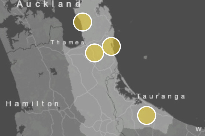 The power outage areas. Image: PowerCo.
EARLIER 9.00am: The Coromandel is expected to be the epicentre of the North Island's bad weather today, with more heavy rain forecast to batter the area.
Several roads are already beginning to flood, according to many reports on social media.
A heavy rain warning is in place until 11pm as a subtropical storm sweeps through.
People have been warned to either head home or be prepared to shelter in place until Sunday, Janurary 8.
"A lot of rainfall over night and a lot more expected today. The hills have had a drenching and as at 4am 191mm of rain had fallen on The Pinnacles and 162.5mm at Castle Rock," says Coromandel's CFM in a Facebook post.
In Auckland, MetService had recorded 12.6mm of rain by 7.30am and had forecasted a total of 62mm to fall throughout the day.
Parts of Auckland have also lost power, according to Vector, including in Titirangi, Stanmore Bay, Paremoremo and the rural area northeast of Helensville.
'In addition to the 50 to 70mm that have already accumulated expect a further 140 to 180mm [of rain],” MetService says in its warning for the Coromandel Peninsula.
MetService's Curtis Hayes says Auckland had become the dividing line between the epicentre of the heavy rain in the Coromandel and isolated showers in Northland.
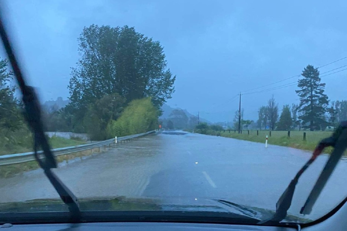
A snapshot of the road flooding near Whitianga. Photo: Caleb Warrender.
Hayes says most of the rain forecast would hit the east of the city.
'The system has shifted a little bit further west than our model shows ... but it looks like Auckland is being spared.”
Hayes says the forecast of 62mm might be on the high side. However, if 62mm did fall for Auckland it would be double what central parts of the city saw on Wednesday and it would likely bring slips and surface flooding.
There had been a strong wind warning in effect overnight until 5am for Auckland, including Great Barrier Island. A heavy rain watch was also in place through till 9am.
On the east coast of the North Island, a heavy rain warning was in effect for Bay of Plenty west of Matata, through till 9am Friday.
'Expect 140 to 200 mm of rain to accumulate. Peak rates of 10 to 20 mm/h expected,” says MetService.
'Note that this warning may be extended since further bursts of heavy rain are possible during the remainder of Friday and into Saturday.”
Heavy rain warnings were also in effect in the South Island, for Tasman northwest of Motueka through till 11am Friday and the ranges of Westland south of Otira through until 4am Friday.
Hayes says the rain was set to continue into the weekend and a cold front would move its way up the country from the south over the next couple of days.
The nice weather over Christmas was to blame, he says, with high pressure system sitting off to the east of the country and not moving, preventing the bad weather from moving off.
Holiday and festival plans thrown into disarray
On Wednesday January 4, the Thames-Coromandel District Council told locals and visitors to 'err on the side of caution” and seek safety in a secure location – or even head home.
'The accumulation of rain by Saturday could see surface flooding, slips, road closures and power issues, so it is worth hatching a plan today to ensure no-one is stuck or isolated,” Thames-Coromandel Civil Defence Controller Garry Towler says earlier.
Stuff understands many people packed up and left Cooks Beach as rain poured down on the Coromandel campsite. Meanwhile, in Northland, Whangaruru Beachfront Camp and Motel owner Robynne Cooper on Wednesday says 'hardly anyone is left” after strong winds and rain hit the campsite.
Others have found themselves out of pocket due to the weather too. A Coromandel tour operator has had to cancel hundreds of summer bookings due to the weather warnings, and two Wellington siblings are $1000 down after a festival was cancelled less than 24 hours from kick-off.
Wet weather across the motu
MetService forecaster Aidan Pyselman says almost nowhere would escape the bad weather this week.
The culprit was a low – a region of air that spirals inwards, bringing wet and windy weathers – sitting in the north of the Tasman Sea.
It couldn't progress and move away from New Zealand because a high pressure system east of the Chatham Islands had 'kind of just parked” there, blocking the low from moving.
It meant wet weather across the motu for at least the rest of the week, and potentially next week too.
'The top of the country is seeing the worst of it at this stage,” says Pyselman.
'There might be some reprieve in the north on Saturday, and it looks like we've got another little low starting up early next week.”
Severe weather hitting your area? Email photos to [email protected].
- Additional reporting by Sapeer Mayron/Stuff.

0 comments
Leave a Comment
You must be logged in to make a comment.