A heavy rain warning remains in place for the Bay of Plenty this morning with predictions of more rain for the next couple of days.
The MetService is forecasting occasional rain and northeasterly winds for the region today.
Tomorrow, rain is expected to become persistent for a time in the afternoon, with fresh northerlies easing in the afternoon.
"A large atmospheric river of warm moist air from the tropics continues to bring extreme amounts of rain to parts of New Zealand today and into the weekend," says a statement from the weather organisation.
A heavy red warning issued for Nelson, Buller, and Westland has now been downgraded to orange.
Orange heavy rain warnings remain in place for other parts of the upper South Island as well as many parts of the North Island.
All the latest severe weather information can be found here http://bit.ly/AllWarnings.
Red warnings are reserved for only the most extreme weather events and require immediate action to protect people, animals, and property from the impacts of the weather.
Decisions on whether to issue red warnings are made in consultation with hydrologists at the regional councils who understand the river flows and the impacts of the amount of rainfall we are forecasting.
Although the rain eased across the upper South Island overnight, another pulse of heavy rain is expected across the area during the second half of today and Saturday morning.
"People that live in the upper South Island should be aware that this event is far from over and there is likely to be more flooding and slips as we head into the weekend," says MetService Meteorologist Stephen Glassey.
As of 10am Thursday morning, more than 600mm of rain had fallen in the Tasman Mountains and over 400mm in some lower lying areas in Tasman and Nelson regions since midnight Monday, and more heavy rain is expected in the next few days.
Another 150 to 200mm is expected in the ranges east of Nelson before 11pm last night, then again in the 24 hours from midday Friday to midday Saturday.
Heavy rain has also brought flooding to the Far North with over 100mm recorded at Kerikeri in Northland in the 12 hours up to 10am Thursday.
Later on Saturday, rain around the country weakens and we are left with more sporadic areas of wet weather, which will be less severe nationwide.
"Having such a prolonged period of tropical moisture over the county during winter is extremely unusual. As well as the extreme rainfall, we have also seen Auckland break its August record for the warmest overnight minimum temperature.
"Auckland airport recorded an overnight minimum of 15.5C Wednesday into Thursday. That's the kind of overnight temperature that you would expect in the middle of Summer"
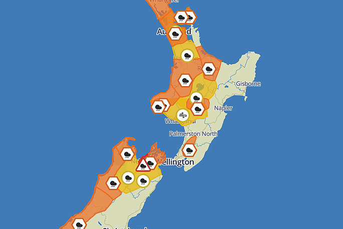 Image: MetService.

0 comments
Leave a Comment
You must be logged in to make a comment.