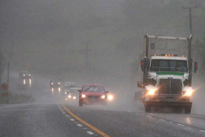
The MetService has issued the latest severe weather watch and warning updates for the Bay of Plenty, as well as the rest of New Zealand.
A severe weather watch and warning is in place the BOP.
A heavy rain watch is in force for the Coromandel with predictions of heavy rain for northern and western part of New Zealand.
A slow-moving complex trough of low pressure, preceded by a moist northerly flow, covers New Zealand, says a spokesperson for the weather organisation.
"The trough is expected to move slowly eastwards across the county late Thursday and during Friday.
"This weather system is forecast to bring an extended period of northerly rain to northern and western parts of New Zealand, where numerous heavy rain warnings and watches are in place. Red Heavy Rain Warnings are in force for Nelson, Buller and Westland.
"In addition, gale to severe gale north to northeasterly winds will affect northern and central parts of New Zealand, and strong wind warnings and watches are in place.
"Please note for the north and west of the South Island, heavy rain is forecast to return Friday afternoon, then ease Saturday afternoon.
"This next period of rain will exceed warning criteria, and probably lead to more surface flooding and slips due to the ground already being saturated from recent heavy rain.
"People are advised to keep up to date with the latest forecasts."
 Image: MetService.
========================
HEAVY RAIN WARNING - RED
========================
This rain is expected to cause dangerous river conditions and significant flooding. Slips and floodwaters are likely to disrupt travel, making some roads impassable and possibly isolating communities.
Area: Buller
Valid: 12 hours from 9am to 9pm Thursday
Forecast: Expect a further 70 to 100 mm of rain to accumulate about the ranges south of Little Wanganui on top of what has already fallen, and 30 to 70 mm elsewhere. Peak rates of 10 to 15 mm/h about the ranges.
Note, heavy rain is forecast to return Friday afternoon, then ease Saturday afternoon. This next period of rain will exceed warning criteria, and probably lead to more surface flooding and slips due to the ground already being saturated from recent heavy rain.
In the 24 hours from Noon Friday to Noon Saturday, expect 80 to 130 mm to accumulate about the ranges. Peak rates of 15 to 25 mm/h.
Area: Nelson District (ie. from Cape Soucis, through Nelson City to Stoke),also the Bryant Range
Valid: 14 hours from 9am to 11pm Thursday
Forecast: Expect a further 150 to 200 mm of rain to accumulate about the ranges on top of what has already fallen, and 40 to 70 mm elsewhere. Peak rates of 10 to 20 mm/h.
Note, heavy rain is forecast to return Friday afternoon, then ease Saturday afternoon. This next period of rain will exceed warning criteria, and probably lead to more surface flooding and slips due to the ground already being saturated from recent heavy rain.
In the 24 hours from Noon Friday to Noon Saturday, expect 140 to 190 mm to accumulate about the Bryant Range, and 50-90 mm elsewhere. Peak rates of 15 to 25 mm/h.
Change note: Bryant Range now included with highest rainfall expected there
Area: Westland
Valid: 13 hours from 9am to 10pm Thursday
Forecast: Expect a further 120 to 160 mm of rain to accumulate about the ranges on top of what has already fallen, especially between Bruce Bay and Otira, and 30 to 60 mm about the coast. Peak rates of
10 to 20 mm/h about the ranges.Thunderstorms possible about the ranges south of Ross this afternoon and evening with localised rainfall rates up to 25 mm/h.
Note, heavy rain is forecast to return Friday afternoon, then ease Saturday afternoon. This next period of rain may exceed warning criteria, and could lead to more surface flooding and slips due to the ground already being saturated from recent heavy rain.
From the glaciers northwards, in the 24 hours from Noon Friday to Noon Saturday,expect 80 to 120 mm to accumulate about the ranges.Peak rates of 15 to 25 mm/h.
===========================
HEAVY RAIN WARNING - ORANGE
===========================
Heavy rain may cause streams and rivers to rise rapidly. Surface flooding and slips are also possible and driving conditions may be hazardous.
Area: Northland
Valid: 24 hours from 9am Thursday to 9am Friday
Forecast: Expect a further 100 to 140 mm of rain to accumulate on top of what has already fallen, especially in the north and east. Peak rates of 10 to 20 mm/h.
Area: Auckland and Great Barrier Island
Valid: 19 hours from 9am Thursday to 4am Friday
Forecast: Expect a further 60 to 90 mm of rain to accumulate on top of what has already fallen. Peak rates of 10 to 20 mm/h.
Area: Bay of Plenty west of Edgecumbe
Valid: 16 hours from 9am Thursday to 1am Friday
Forecast: Expect a further 80 to 120 mm to accumulate on top of what has already.Peak rates of 10 to 20 mm/h.
Area: Waikato south of Raglan, Waitomo, Taumarunui
Valid: 23 hours from 9am Thursday to 8am Friday
Forecast: Expect a further 120 to 180 mm of rain to accumulate on top of what has already fallen, especially in western areas. Peak rates of 10 to 20 mm/h.
Area: North Taranaki away from the Mountain
Valid: 25 hours from 9am Thursday to 10am Friday
Forecast: Expect a further 100 to 170 mm of rain to accumulate on top of what has already fallen. Peak rates of 10 to 20 mm/h.
Area: Tongariro National Park
Valid: 23 hours from 9am Thursday to 8am Friday
Forecast: Expect a further 120 to 200 mm of rain to accumulate on top of what has already fallen. Peak rates of 10 to 15 mm/h.
Area: Mount Taranaki
Valid: 37 hours from 9am Thursday to 10pm Friday
Forecast: Expect a further 350 to 500 mm of rain to accumulate on top of what has already fallen. Peak rates of 15 to 25 mm/h.
Area: The Tasman District west of Motueka
Valid: 12 hours from 9am to 9pm Thursday
Forecast: Expect a further 120 to 150 mm of rain to accumulate about the ranges on top of what has already fallen, and 50 to 80 mm about low lying areas. Peak rates of 10 to 20 mm/h about the ranges.
Note, heavy rain is forecast to return Friday afternoon, then ease Saturday afternoon. This next period of rain will exceed warning criteria, and probably lead to more surface flooding and slips due to the ground already being saturated from recent heavy rain.
In the 24 hours from Noon Friday to Noon Saturday, expect 160 to 220 mm to accumulate about the ranges. Peak rates of 20 to 30 mm/h.
Area: The Tararua Range
Valid: 32 hours from 11am Thursday to 7pm Friday
Forecast: Expect 120 to 180 mm of rain. Peak rates of 10 to 15 mm/h.
Area: The Marlborough Sounds, Rai Valley and the Richmond Range
Valid: 14 hours from 9am to 11pm Thursday
Forecast: Expect a further 150 to 200 mm of rain to accumulate about the ranges on top of what has already fallen, and 60 to 100 mm elsewhere. Peak rates of 10 to 20 mm/h about the ranges.
Note, heavy rain is forecast to return Friday afternoon, then ease Saturday afternoon. This next period of rain will exceed warning criteria, and probably lead to more surface flooding and slips due to the ground already being saturated from recent heavy rain.
In the 24 hours from Noon Friday to Noon Saturday, expect 140 to 190 mm to accumulate about the ranges. Peak rates of 15 to 25 mm/h.
============================
STRONG WIND WARNING - ORANGE
============================
Strong wind gusts could damage trees, powerlines and unsecured structures.Driving may be hazardous, especially for high-sided vehicles and motorcycles.
Area: Northland
Valid: 9 hours from 9am to 6pm Thursday
Forecast: Northeast gales are forecast to be severe at times, with gusts reaching 120 km/h in exposed places.
HEAVY RAIN WATCH
Area: Coromandel Peninsula
Valid: 13 hours from 9am to 10pm Thursday
Forecast: Periods of heavy rain. Rainfall amounts may approach warning criteria.
Area: Waikato about and north of Raglan, Taupo and Taihape west of Tongariro National Park
Valid: 23 hours from 9am Thursday to 8am Friday
Forecast: Periods of heavy rain. Rainfall amounts may exceed warning criteria.
Area: Bay of Plenty about and east of Edgecumbe
Valid: 13 hours from 9am to 10pm Thursday
Forecast: Periods of heavy rain. Rainfall amounts may approach warning criteria.
Area: The Tasman District from Motueka eastwards, excluding Nelson District
Valid: 13 hours from 9am to 10pm Thursday
Forecast: Periods of heavy rain. Rainfall amounts may approach warning criteria.
Area: Marlborough northwest of the Inland Kaikoura Range and south of the Richmond Range
Valid: 12 hours from 9am to 9pm Thursday
Forecast: Periods of heavy rain, especially about the ranges.Rainfall amounts may approach warning criteria.
Note, lower accumulations are expected in the Wairau Valley, but there is still potential for flooding from heavy rain in the surrounding ranges.
Area: The headwaters of the Canterbury lakes and rivers
Valid: 9 hours from 9am to 6pm Thursday
Forecast: Periods of heavy rain. Rainfall amounts may approach warning criteria within 15km east of the main divide.
STRONG WIND WATCH
Area: Auckland and Great Barrier Island
Valid: 10 hours from 9am to 7pm Thursday
Forecast: Northeast winds may approach severe gale in exposed places at times.
Area: Taranaki about and south of the Mountain, Whanganui and Taihape
Valid: 20 hours from 9am Thursday to 5am Friday
Forecast: North to northeast winds may approach severe gale in exposed places at times.
Area: Nelson, Tasman and Buller
Valid: 9 hours from 9am to 6pm Thursday
Forecast: Northeast winds may approach severe gale at times. Winds easing in Buller early afternoon.

0 comments
Leave a Comment
You must be logged in to make a comment.