


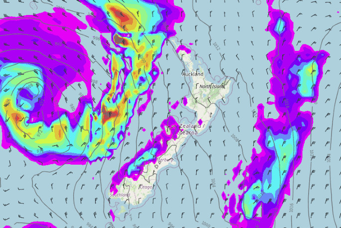
There are two significant storm systems in the New Zealand area this week, with one storm having passed through on Monday and the second due to arrive on Tuesday evening.
The first storm on Monday was tracking southwards over the Tasman Sea with air pressure deeper than most ex-tropical cyclones that reach NZ, says a WeatherWatch spokesperson.
WeatherWatch have labelled the two storms 'May' and 'June' as they are peaking in strength in each month.
"While Storm 2 later on Tuesday/Wednesday will be in a similar position but it will be tracking west to east from Tasmania to the South Island of NZ."
The second storm is expected to fall apart over NZ bringing days of wind and rain, and not easing until Queen's Birthday Weekend.
"It's likely to create widespread severe weather," says a WeatherWatch spokesperson.
MetService has issued a severe weather warning on Tuesday morning with heavy rain and possible severe gales forecast for parts of the country.
"An active front is forecast to move quickly southeast across New Zealand overnight tonight," says a MetService spokesperson.
"Brief heavy rain and strong northeasterlies are expected ahead of the front for many places, followed by the risk of heavy rain and severe gale northwesterlies across parts of central and southern New Zealand."
A heavy rain warning is in place for the ranges of Tasman west of Motueka from 9pm Tuesday to 3am Wednesday; for Buller from 10pm Tuesday to 6am Thursday; and for Westland from 12am Wednesday to 3pm Thursday.
Storm 1, labelled 'May' - dropped to 959hPa on Monday, whereas Storm 2, labelled 'June' - is expected to drop to an estimated 962hPa on Wednesday.
Here's the Lowdown on the twin storms.
— WeatherWatch.co.nz (@WeatherWatchNZ) May 30, 2022
We've decided they should be named 'May' & 'June' (especially because they peak in strength in each month!). Storm1 (May): Drops to an incredible 959hPa right now (3pm Monday).Storm2 (June): Drops to an estimated 962 Wednesday. pic.twitter.com/GUqAJqfwRM
WeatherWatch has detailed coverage of the two storms impacting New Zealand showing their forecast until Saturday:
After a calm weekend across New Zealand, rain has arrived for many parts of the country since Sunday evening and MetService meteorologists expect the unsettled weather to continue this week with several wet and windy systems passing over the country.
"It's been a wet start to the work week for many Kiwis thanks to a low pressure system out in the Tasman Sea which has caused warm, moist air from the north to move over the country," says a MetService spokesperson.
"This has also resulted in heavy falls of rain from Northland to Coromandel and spreading to Bay of Plenty on Monday afternoon.
"Tuesday will start off a little more settled although showers are expected for the western parts of both island."
By evening another low in the Tasman will bring the next bout of warm and wet weather to the north and west, and by Wednesday morning all regions are likely to have received at least some rain.
'It won't only be the wet weather that will have people talking," says MetService meteorologist Luis Fernandes.
"The tropically sourced air being drawn down from the north will also have a noticeable effect on New Zealand's temperatures, as minimum temperatures in particular, will be much higher than normal for this time of the year.”
Not much changes into Wednesday and Thursday with many areas, mainly in the west, remaining wet. A southwest flow eventually takes over later Thursday, heralding the start of the cooler air returning.
'This means temperatures return to what we would normally expect for late May and early June, but the rain doesn't clear just yet, as the colder southwest circulation will still bring showers through to Friday and Saturday”, says Luis.
Over the weekend, a ridge of high pressure gradually shifts toward New Zealand, resulting in a gradual clearance and a return to more settled conditions.

0 comments
Leave a Comment
You must be logged in to make a comment.