
Warm nights and a blood moon will be topics of dicussion for many people this morning.
Last night's blood moon - a total lunar eclipse causing the moon to turn red - was captured on camera by a Katikati resident.
Photos sent to SunLive show the moon sitting high above the Katikati estuary at 5.45pm on Monday (See photo below).

Blood Moon is not a scientific term, though in recent times it is being widely used to refer to a total lunar eclipse because a fully eclipsed moon often takes on a reddish color.
While many would have observed the moon, others would have noticed the warm overnight temperatures as well.
MetService forecasted last night's temperaure in the Bay of Plenty to be more than 8 degrees above the normal May average.
The weather ogranisation says this is being caused by a series of fronts moving over the country this week.
'The westerly flow bringing in humid air, means any fronts moving over the country this week will be ripe for rain, and this pattern will dominate through to Friday,” says MetService meteorologist April Clark.
 A rainbow before the rain over the Western Bay of Plenty this morning.
Each front will bring a period of rain to regions exposed to the west, with lesser amounts in the east.
Winds are also expected to pick up with the passage of each front, especially over the high country with Wellington's break from gale force winds set to be broken on Thursday when an active front moves up from the South Island.
'The humid air not only brings rain, but also unusually warm overnight temperatures to Aotearoa, especially for the upper North Island.
'Warmer ambient temperatures in conjunction with cloudy skies mean the forecast overnight temperatures for the Bay of Plenty, Auckland and Northland regions on Tuesday are as much as 8C above their May average.
'17°C overnight for Auckland on Tuesday is almost bang on the average daily high temperature for May, and is a marked change from the low single digits of last week.”
An active front is expected to move over the country on Thursday, marking the start of a gradual shift to southwesterlies and cooler temperatures.
Eastern regions of the South Island will likely see the sharpest drop in temperatures from the week's start to end, with single digit maximum temperatures showing up for Southland and Otago on Friday.
Unsettled weather means changeable weather so it becomes even more important to keep up with the details of the latest Severe Weather Warnings and your local forecast as the weather you wake up to each morning is unlikely to be the same by afternoon.
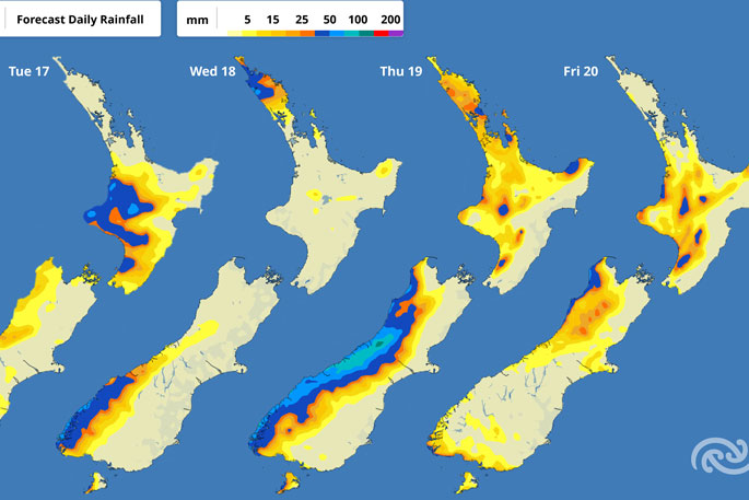 Image: MetService.

0 comments
Leave a Comment
You must be logged in to make a comment.