While the weather forecast is for a mainly fine day for the Bay of Plenty, the MetService has issued a severe weather watch for other parts of the country.
Heavy rain and northwest gales are expected in parts of central and southern New Zealand
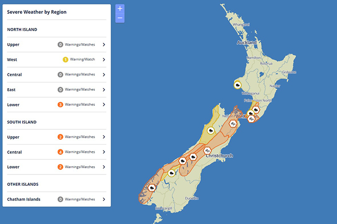
A series of fronts are expected to affect central and southern New Zealand from tonight through to Sunday, bringing periods of heavy rain and strong northwesterly winds.
The heaviest rain is expected in Fiordland, the ranges of Westland south of Otira, the headwaters of Canterbury Lakes and Rivers from Arthurs Pass southwards, and now also the Tararua Range, where Heavy Rain Warnings - marked on the map in orange - are in force. Meanwhile, Heavy Rain Watches are in force for the headwaters of the Otago Lakes and Rivers, the ranges of Westland from Otira northwards, the ranges of Buller, and now also Wellington, Horowhenua, Kapiti Coast, and Mount Taranaki.
In addition, Strong Wind Warnings - marked on the map in orange - remain in force for the Canterbury High Country, inland Marlborough including the Sounds, Wellington and southern Wairarapa.
People are advised to keep up to date with the latest forecasts in case any changes are made or further areas are added.
Heavy Rain Warning:
Heavy rain may cause streams and rivers to rise rapidly. Surface flooding and slips are also possible and driving conditions may be hazardous.
Area: The Tararua Range
Valid: 38 hours from 9am Saturday to 11pm Sunday
Forecast: Periods of heavy rain. Expect 120 to 180mm of rain to accumulate on top of what has already fallen. Peak rates of 10 to 20 millimetres per hour expected during Sunday.
Changes: Upgraded to a Warning (Orange)
Area: The ranges of Westland south of Otira
Valid: 14 hours from 9am to 11pm Saturday
Forecast: Periods of heavy rain. Expect a further 90 to 130 mm of rain to accumulate on top of what has already fallen. Peak rates of 15 to 25 millimetres per hour expected Saturday morning and afternoon, and thunderstorms possible.
Heavy Rain Watch:
Area: Kapiti-Horowhenua and Wellington
Valid: 20 hours from 3am to 11pm Sunday
Forecast: Periods of heavy rain. Rainfall amounts may approach warning criteria, especially from Porirua and the Hutt Valley northwards.
Heavy Rain Warning
Heavy rain may cause streams and rivers to rise rapidly. Surface flooding and slips are also possible and driving conditions may be hazardous.
Area: The headwaters of the Canterbury Lakes and Rivers from Arthurs Pass southwards
Valid: 14 hours from 9am to 11pm Saturday
Forecast: Periods of heavy rain. Expect a further 80 to 120 mm of rain to accumulate within 15km east of the divide, on top of what has already fallen. Peak rates of 15 to 25 millimetres per hour Saturday morning and afternoon, and thunderstorms possible.
Area: Fiordland (mainly from Doubtful Sound northwards)
Valid: 8 hours from 9am to 5pm Saturday
Forecast: Periods of heavy rain. Expect a further 60 to 80mm of rain to accumulate on top of what has already fallen. Peak rates of 10 to 15 millimetres per hour, and thunderstorms possible.
Strong Wind Warning
Strong wind gusts could damage trees, powerlines and unsecured structures. Driving may be hazardous, especially for high-sided vehicles and motorcycles.
Area: Inland Marlborough including the Sounds
Valid: 16 hours from 9am Saturday to 1am Sunday
Forecast: Northwest gales are forecast to be severe at times, with gusts reaching 120 kilometres per hour in exposed places.
Area: Wellington, and Wairarapa from Featherston southwards
Valid: 16 hours from 11am Saturday to 3am Sunday
Forecast: Northwest gales are forecast to be severe at times, with gusts reaching 120 kilometres per hour in exposed places.
Area: Canterbury High Country
Valid: 14 hours from 9am to 11pm Saturday
Forecast: Northwest gales are forecast to be severe at times, with gusts reaching 120 kilometres per hour in exposed places.
Heavy Rain Watch
Area: The ranges of Westland from Otira northwards, and the ranges of Buller
Valid: 14 hours from 11am Saturday to 1am Sunday
Forecast: Periods of heavy rain, and thunderstorms possible. Rainfall amounts may approach short duration warning criteria.
Area: The headwaters of the Otago Lakes and Rivers
Valid: 9 hours from 9am to 6pm Saturday
Forecast: Periods of heavy rain, and thunderstorms possible. Rainfall amounts may approach warning criteria within 15km east of the main divide.
Area: Mount Taranaki
Valid: 8 hours from 3pm to 11pm Sunday
Forecast: Periods of heavy rain. Rainfall amounts may approach warning criteria.

0 comments
Leave a Comment
You must be logged in to make a comment.