 |
Weather Eye with John Maunder |
El Niño and La Niña are complex weather patterns resulting from variations in ocean temperatures in the Equatorial Pacific.
El Niño and La Niña are opposite phases of what is known as the El Niño-Southern Oscillation (ENSO) cycle.
La Niña is sometimes referred to as the cold phase of the ENSO cycle, and El Niño as the warm phase of ENSO. These deviations from normal surface temperatures can have large-scale impacts not only on ocean processes, but also on global weather and climate.
El Niño and La Niña episodes typically last nine to 12 months, but some prolonged events may last for years. While their frequency can be quite irregular, El Niño and La Niña events occur on average every two to seven years. Typically, El Niño occurs more frequently than La Niña.
El Niño
El Niño means The Little Boy, or Christ Child in Spanish. El Niño was originally recognized by fishermen off the coast of South America in the 1600's, with the appearance of unusually warm water in the Pacific Ocean. The name was chosen based on the time of year (around December) during which these warm waters events tended to occur.
The term El Niño refers to the large-scale ocean-atmosphere climate interaction linked to a periodic warming in sea surface temperatures across the central and east-central Equatorial Pacific.
The presence of El Niño can significantly influence weather patterns, ocean conditions, and marine fisheries across large portions of the globe for an extended period of time.
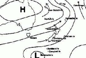
A typical El Nino weather pattern (Source NIWA)
La Niña
La Niña means The Little Girl in Spanish. La Niña is also sometimes called El Viejo, anti-El Niño, or simply "a cold event."
La Niña episodes represent periods of below-average sea surface temperatures across the east-central Equatorial Pacific. Global climate La Niña impacts tend to be opposite those of El Niño impacts. In the tropics, ocean temperature variations in La Niña also tend to be opposite those of El Niño.
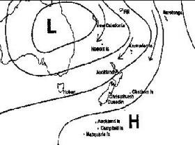
A typical La Nina weather pattern (source NIWA)
El Nino and La Nina weather affects over New Zealand (source Niwa)
During El Niño, New Zealand tends to experience stronger or more frequent winds from the west in summer, typically leading to drought in east coast areas and more rain in the west. In winter, the winds tend to be more from the south, bringing colder conditions to both the land and the surrounding ocean. In spring and autumn south–westerly winds are more common.
La Niña events have different impacts on New Zealand's climate. More north–easterly winds are characteristic, which tend to bring moist, rainy conditions to the north–east of the North Island, and reduced rainfall to the south and south–west of the South Island. Therefore, some areas, such as central Otago and South Canterbury, can experience drought in both El Niño and La Niña. Warmer than normal temperatures typically occur over much of the country during La Niña, although there are regional and seasonal exceptions.
Although ENSO events have an important influence on New Zealand's climate, it accounts for less than 25% of the year to year variance in seasonal rainfall and temperature at most New Zealand measurement sites. East coast droughts may be common during El Niño events, but they can also happen in non El Niño years (for example, the severe 1988–89 drought). Also, serious east coast droughts do not occur in every El Niño. However, the probabilities of the climate variations discussed above happening in association with ENSO events are sufficient to warrant management actions and planning to be taken when an El Niño or La Niña is expected or in progress.
For further information on a range of weather and climate matters see: https://sites.google.com/site/theuncertaintybusinessclimate/
