Drivers in the Eastern Bay of Plenty are being asked to avoid State Highway 35 after a landslip left debris strewn across part of the road this morning.
As a direct result of Cyclone Pam, parts of the highway are also taking on sea water as high winds and extensive swells push surf over the road in several locations.
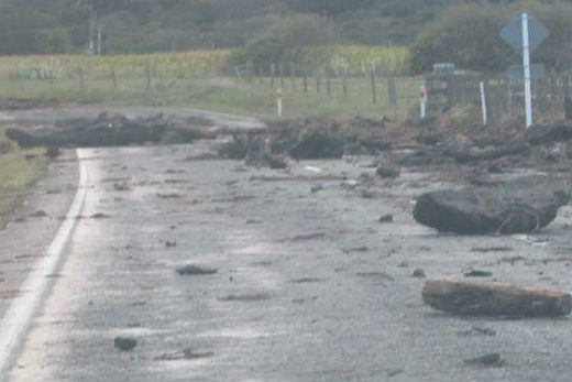
Drivers are being warned that SH35 in the Eastern Bay is covered with debris in sections and is blocked at Waihou Bay. Photo: Pauline Houia.
Reader Pauline Houia took these photos in Omaio and Otuwhare this morning, which clearly show some of the debris that has sparked the warning.
The warning covers the area from Hawai, south of the Motu river mouth, and up past Te Kaha to Waihau Bay.
Driftwood and debris is currently scattered along the highway and high surf is breaking over the road in several low lying Locations.
A brief statement from police says: 'State Highway 35 is blocked at Waihou Bay due to a slip. An estimated time to clear is two-to-three hours.”
Storm has closed SH35 between Orete Point Rd & Waihau Bay campground. If you have to venture out watch out for falling trees & other hazards
— Bay of Plenty Police (@BOPPolice) March 15, 2015New Zealand Transport Agency added: 'Debris is scattered along the highway and the sea is breaking over the road in several locations.
'The situation is likely to worsen as the weather impact increases, especially as high-tide approaches mid-afternoon.
'The road is likely to be impassable at times, especially for non-4wd cars and motorcycles. Drive with extreme care.”
As of 10am this morning, Cyclone Pam was located about 230 km east-northeast of East Cape, Gisborne.
Despite being re-classified as an extra-tropical cyclone in the early hours of this morning, the system is still sparking some severe weather which is affecting parts of the North Island.
MetService reports the system is moving south and should lie about 180 km east of East Cape by around 1pm today, and just northeast of the Chatham Islands around 1pm on Tuesday.
It is expected to maintain its intensity or even intensify slightly as it moves southeast.
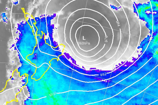
Former Tropical cyclone Pam as at 10am today. Image: MetService.

0 comments
Leave a Comment
You must be logged in to make a comment.