The latest track guestimates for Tropical Cyclone Lusi might offer some good news for the Bay of Plenty, but not so much for the upper South Island.
The eye of the storm is now predicted to pass down the North Island west coast. Earlier forecasts had the storm centre coming down the east coast and crossing over to the Taranaki bight at Auckland or Northland.
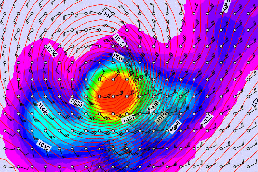
a Metvuw rain and air pressure map for 1am Sunday, March, 16.
It means the seriously heavy rainfall of more than 20mm per hour lying closer to the eye will now cross over the far north instead of the Coromandel and Bay of Plenty bearing the brunt.
The heaviest rain is now expected to accompany the eye of the storm down the North Island west coast affecting Taranaki and the top half of the South Island, including Nelson, Marlborough and Canterbury.
For Tauranga it means that instead of strong south east winds, easterly winds of near gale force are expected with rain, for Saturday. The wind is expected to back around to the north east Sunday morning, and be blowing at 20-25 knots straight through the harbour entrance by Sunday evening.
The forecasted storm track is still subject to change.
Despite the latest track changes a number of warnings remain in place heading into the wet and windy weather.
The Ministry of Civil Defence is still advising people to make sure they put away outdoor furniture and secure heavy items while boaties are being urged to be prepared for severe weather and make sure their boats are secured.
Tropical Cyclone Lusi is being monitored by the Ministry of Civil Defence as it moves from Vanuatu, past Fiji to New Zealand. They expect Lusi to arrive over northern New Zealand on Saturday or early Sunday, and then to track southwards over central New Zealand before moving out to sea east of the South Island on Monday.
While the cyclone is expected to change to a sub-tropical weather system as it approaches New Zealand, it's still expected to be a dangerous storm, with severe weather is likely to affect many regions from Northland down to Canterbury.

0 comments
Leave a Comment
You must be logged in to make a comment.