Visiting boaties are advised the channel across the Bowentown Bar has shifted significantly since last summer.
A survey carried out in November identified some significant changes to the shape and extent of the outer banks of the bar at the Tauranga Harbour Northern Entrance, says Tauranga Harbourmaster Jennifer Roberts.
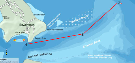
The Bowentown Bar. Waypoints at bottom of article.
The southernmost route, passing close to Matakana Islalnd is now shoaled and no longer recommended for use.
The two yellow buoys still indicate the best route. The seaward buoy will be moved 300-400m SE to avoid boats running too close to the northern shoals. Minimum depths of between 2.4-2.6 m can be expected over the outer shoals when using this route.
'With assistance from the local coastguard we will continue to monitor the bar, particularly after storms and heavy rainfall, so we can inform people about any changes and help reduce the risks associated with crossing the bar,” says Jennifer.
'We've identified some significant changes to the shape and extent of the outer banks of the Bowentown Bar since we carried out this survey a year ago.
'One route, which was previously identified as Route B, has now shoaled and is no longer recommended for use.
'The two yellow safe buoys still indicate the best route, although we will be moving the seaward buoy 300-400m to the SE in order to avoid vessels running too close to the northern shoals. Boaties can expect minimum depths of between 2.4-2.6m over the outer shoals when transitioning through this route.
Waypoint positions:
1: 37°28.173´ S, 175° 59.112´ E
2: 37°28.010´ S, 176° 00.224´ E
3: 37°27.506´ S, 176° 00.916´ E
For more information contact the Waihi Beach Coastguard on VHF channel 16 or 85, or phone 07 863 4477.

0 comments
Leave a Comment
You must be logged in to make a comment.